You are here: Home > Network List > TA - USArray Transportable Network (new EarthScope stations) Stations List
> Station H13A Challis, ID, USA > Earthquake Result Viewer
H13A Challis, ID, USA - Earthquake Result Viewer
| Earthquake location: |
Near Coast Of Northern Peru |
| Earthquake latitude/longitude: |
-6.6/-81.2 |
| Earthquake time(UTC): |
2009/02/09 (040) 14:09:02 GMT |
| Earthquake Depth: |
15 km |
| Earthquake Magnitude: |
5.5 MB, 5.5 MS, 6.0 MW, 5.9 MW |
| Earthquake Catalog/Contributor: |
WHDF/NEIC |
|
| Network: |
TA USArray Transportable Network (new EarthScope stations) |
| Station: |
H13A Challis, ID, USA |
| Lat/Lon: |
44.56 N/114.25 W |
| Elevation: |
1563 m |
|
| Distance: |
59.0 deg |
| Az: |
332.896 deg |
| Baz: |
140.71 deg |
| Ray Param: |
0.062485002 |
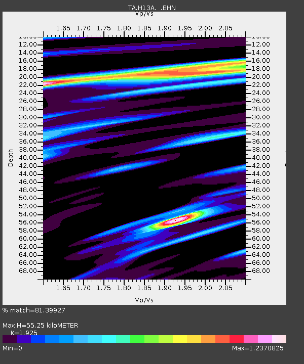
| Estimated Moho Depth: |
55.25 km |
| Estimated Crust Vp/Vs: |
1.92 |
| Assumed Crust Vp: |
6.577 km/s |
| Estimated Crust Vs: |
3.417 km/s |
| Estimated Crust Poisson's Ratio: |
0.32 |
|
| Radial Match: |
81.39927 % |
| Radial Bump: |
400 |
| Transverse Match: |
74.78856 % |
| Transverse Bump: |
400 |
| SOD ConfigId: |
2658 |
| Insert Time: |
2010-03-06 14:07:16.518 +0000 |
| GWidth: |
2.5 |
| Max Bumps: |
400 |
| Tol: |
0.001 |
|
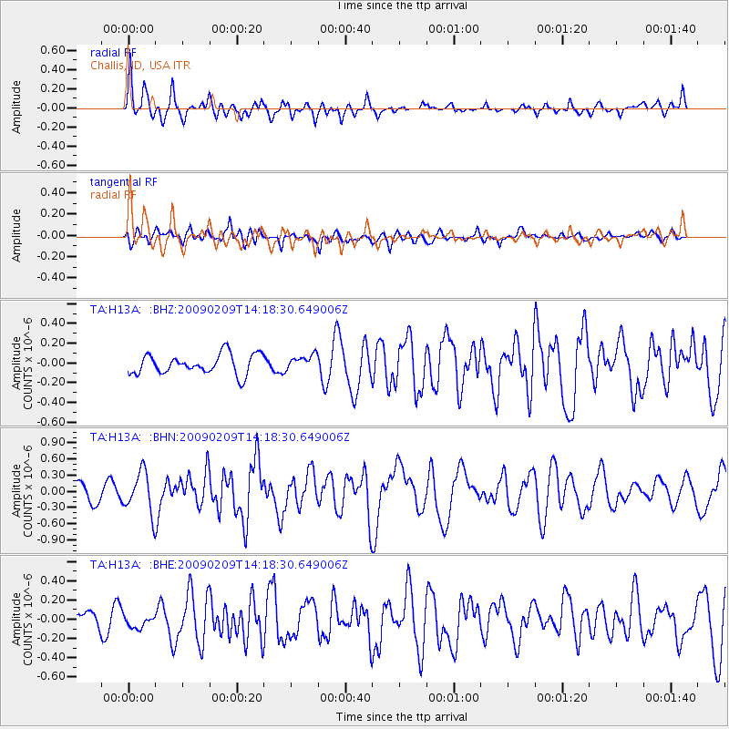
Signal To Noise
| Channel | StoN | STA | LTA |
| TA:H13A: :BHN:20090209T14:18:30.649006Z | 2.2462952 | 3.8384073E-7 | 1.7087724E-7 |
| TA:H13A: :BHE:20090209T14:18:30.649006Z | 0.3403805 | 6.6634726E-8 | 1.957654E-7 |
| TA:H13A: :BHZ:20090209T14:18:30.649006Z | 0.75044286 | 7.588603E-8 | 1.0112166E-7 |
| Arrivals |
| Ps | 8.1 SECOND |
| PpPs | 23 SECOND |
| PsPs/PpSs | 32 SECOND |


