You are here: Home > Network List > TA - USArray Transportable Network (new EarthScope stations) Stations List
> Station H13A Challis, ID, USA > Earthquake Result Viewer
H13A Challis, ID, USA - Earthquake Result Viewer
| Earthquake location: |
Kuril Islands |
| Earthquake latitude/longitude: |
46.0/151.4 |
| Earthquake time(UTC): |
2009/04/18 (108) 19:17:58 GMT |
| Earthquake Depth: |
35 km |
| Earthquake Magnitude: |
6.3 MB, 6.3 MS, 6.6 MW, 6.4 MW |
| Earthquake Catalog/Contributor: |
WHDF/NEIC |
|
| Network: |
TA USArray Transportable Network (new EarthScope stations) |
| Station: |
H13A Challis, ID, USA |
| Lat/Lon: |
44.56 N/114.25 W |
| Elevation: |
1563 m |
|
| Distance: |
62.4 deg |
| Az: |
53.578 deg |
| Baz: |
308.328 deg |
| Ray Param: |
0.060221955 |
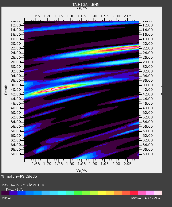
| Estimated Moho Depth: |
39.75 km |
| Estimated Crust Vp/Vs: |
1.72 |
| Assumed Crust Vp: |
6.577 km/s |
| Estimated Crust Vs: |
3.829 km/s |
| Estimated Crust Poisson's Ratio: |
0.24 |
|
| Radial Match: |
93.28665 % |
| Radial Bump: |
400 |
| Transverse Match: |
84.495705 % |
| Transverse Bump: |
400 |
| SOD ConfigId: |
2760 |
| Insert Time: |
2010-03-06 14:07:21.647 +0000 |
| GWidth: |
2.5 |
| Max Bumps: |
400 |
| Tol: |
0.001 |
|
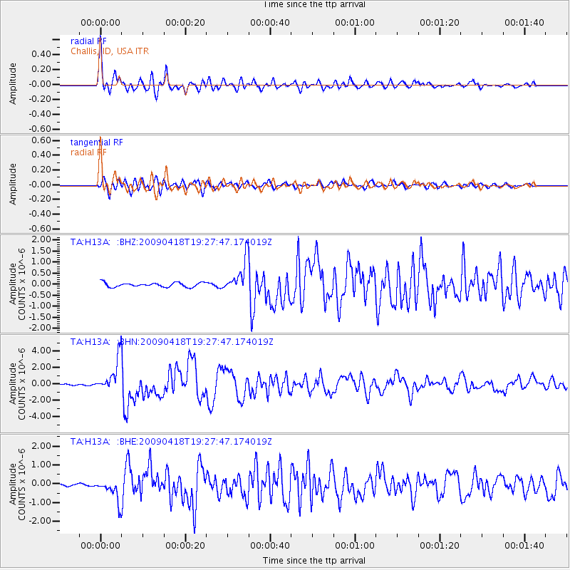
Signal To Noise
| Channel | StoN | STA | LTA |
| TA:H13A: :BHN:20090418T19:27:47.174019Z | 12.717281 | 2.1003507E-6 | 1.651572E-7 |
| TA:H13A: :BHE:20090418T19:27:47.174019Z | 6.9013534 | 6.080276E-7 | 8.810267E-8 |
| TA:H13A: :BHZ:20090418T19:27:47.174019Z | 7.8555827 | 7.496493E-7 | 9.542886E-8 |
| Arrivals |
| Ps | 4.6 SECOND |
| PpPs | 16 SECOND |
| PsPs/PpSs | 20 SECOND |


