You are here: Home > Network List > TA - USArray Transportable Network (new EarthScope stations) Stations List
> Station H13A Challis, ID, USA > Earthquake Result Viewer
H13A Challis, ID, USA - Earthquake Result Viewer
| Earthquake location: |
Loyalty Islands |
| Earthquake latitude/longitude: |
-20.1/168.9 |
| Earthquake time(UTC): |
2008/04/09 (100) 12:46:12 GMT |
| Earthquake Depth: |
33 km |
| Earthquake Magnitude: |
6.3 MB, 7.3 MS, 7.3 MW, 7.3 MW |
| Earthquake Catalog/Contributor: |
WHDF/NEIC |
|
| Network: |
TA USArray Transportable Network (new EarthScope stations) |
| Station: |
H13A Challis, ID, USA |
| Lat/Lon: |
44.56 N/114.25 W |
| Elevation: |
1563 m |
|
| Distance: |
94.9 deg |
| Az: |
44.319 deg |
| Baz: |
246.745 deg |
| Ray Param: |
0.040905654 |
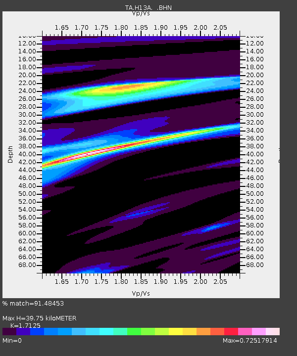
| Estimated Moho Depth: |
39.75 km |
| Estimated Crust Vp/Vs: |
1.71 |
| Assumed Crust Vp: |
6.577 km/s |
| Estimated Crust Vs: |
3.841 km/s |
| Estimated Crust Poisson's Ratio: |
0.24 |
|
| Radial Match: |
91.48453 % |
| Radial Bump: |
290 |
| Transverse Match: |
81.36973 % |
| Transverse Bump: |
377 |
| SOD ConfigId: |
2504 |
| Insert Time: |
2010-03-06 14:07:29.659 +0000 |
| GWidth: |
2.5 |
| Max Bumps: |
400 |
| Tol: |
0.001 |
|

Signal To Noise
| Channel | StoN | STA | LTA |
| TA:H13A: :BHN:20080409T12:59:00.199004Z | 5.6455145 | 1.2598102E-6 | 2.2315244E-7 |
| TA:H13A: :BHE:20080409T12:59:00.199004Z | 0.9414559 | 1.2998368E-7 | 1.3806665E-7 |
| TA:H13A: :BHZ:20080409T12:59:00.199004Z | 0.4807372 | 1.7206212E-7 | 3.5791305E-7 |
| Arrivals |
| Ps | 4.4 SECOND |
| PpPs | 16 SECOND |
| PsPs/PpSs | 20 SECOND |


