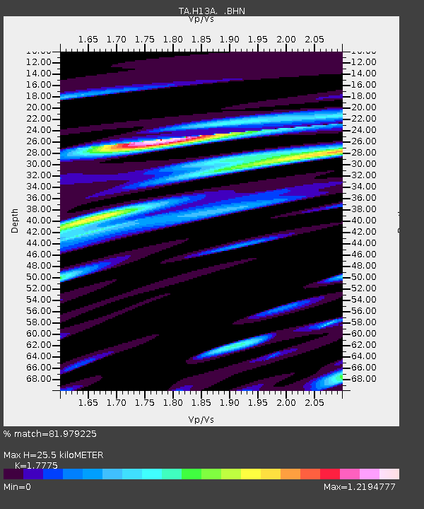
H13A Challis, ID, USA - Earthquake Result Viewer

Earthquake location: Rat Islands, Aleutian Islands
Earthquake latitude/longitude: 51.2/178.8
Earthquake time(UTC): 2008/05/20 (141) 13:53:35 GMT
Earthquake Depth: 27 km
Earthquake Magnitude: 5.8 MB, 6.0 MS, 6.3 MW, 6.3 MW
Earthquake Catalog/Contributor: WHDF/NEIC
Network: TA USArray Transportable Network (new EarthScope stations)
Station: H13A Challis, ID, USA
Lat/Lon: 44.56 N/114.25 W
Elevation: 1563 m
Distance: 44.0 deg
Az: 71.257 deg
Baz: 303.47 deg
Ray Param: 0.07213435
Estimated Moho Depth: 25.5 km
Estimated Crust Vp/Vs: 1.78
Assumed Crust Vp: 6.577 km/s
Estimated Crust Vs: 3.7 km/s
Estimated Crust Poisson's Ratio: 0.27
Radial Match: 81.979225 %
Radial Bump: 400
Transverse Match: 71.24447 %
Transverse Bump: 400
SOD ConfigId: 2504
Insert Time: 2010-03-06 14:07:41.480 +0000
GWidth: 2.5
Max Bumps: 400
Tol: 0.001

Signal To Noise

ChannelStoNSTALTA
TA:H13A: :BHN:20080520T14:01:10.050004Z5.3702254.620353E-78.603649E-8
TA:H13A: :BHE:20080520T14:01:10.050004Z1.93755761.9844632E-71.0242086E-7
TA:H13A: :BHZ:20080520T14:01:10.050004Z6.7140853.2779823E-74.882247E-8
Arrivals
Ps3.2 SECOND
PpPs10 SECOND
PsPs/PpSs13 SECOND