You are here: Home > Network List > N4 - Central and EAstern US Network Stations List
> Station P46A Rosedale, IN, USA > Earthquake Result Viewer
P46A Rosedale, IN, USA - Earthquake Result Viewer
| Earthquake location: |
Costa Rica |
| Earthquake latitude/longitude: |
8.8/-83.2 |
| Earthquake time(UTC): |
2018/08/17 (229) 23:22:24 GMT |
| Earthquake Depth: |
15 km |
| Earthquake Magnitude: |
6.1 Mww |
| Earthquake Catalog/Contributor: |
NEIC PDE/us |
|
| Network: |
N4 Central and EAstern US Network |
| Station: |
P46A Rosedale, IN, USA |
| Lat/Lon: |
39.62 N/87.21 W |
| Elevation: |
194 m |
|
| Distance: |
30.9 deg |
| Az: |
353.902 deg |
| Baz: |
172.187 deg |
| Ray Param: |
0.07919645 |
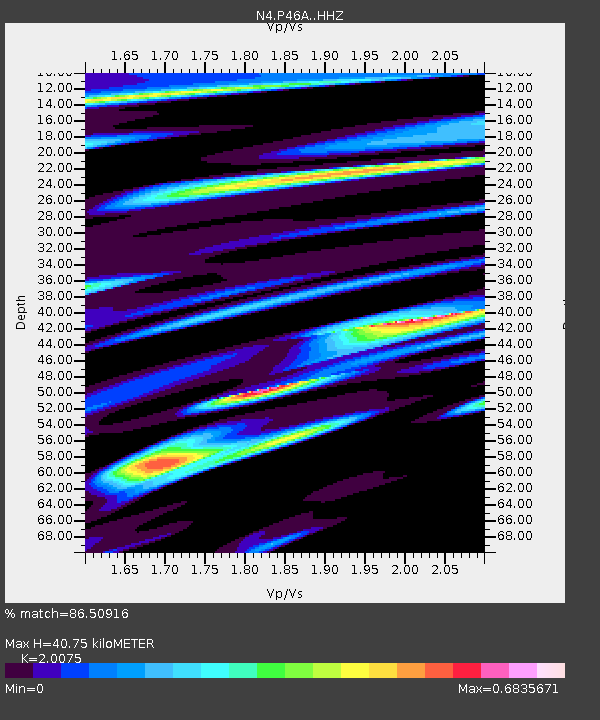
| Estimated Moho Depth: |
40.75 km |
| Estimated Crust Vp/Vs: |
2.01 |
| Assumed Crust Vp: |
6.444 km/s |
| Estimated Crust Vs: |
3.21 km/s |
| Estimated Crust Poisson's Ratio: |
0.33 |
|
| Radial Match: |
86.50916 % |
| Radial Bump: |
394 |
| Transverse Match: |
36.52909 % |
| Transverse Bump: |
400 |
| SOD ConfigId: |
13570011 |
| Insert Time: |
2019-04-30 20:34:35.321 +0000 |
| GWidth: |
2.5 |
| Max Bumps: |
400 |
| Tol: |
0.001 |
|

Signal To Noise
| Channel | StoN | STA | LTA |
| N4:P46A: :HHZ:20180817T23:28:10.38999Z | 23.660944 | 1.8598975E-6 | 7.860623E-8 |
| N4:P46A: :HHN:20180817T23:28:10.38999Z | 3.6186254 | 1.1918327E-6 | 3.293606E-7 |
| N4:P46A: :HHE:20180817T23:28:10.38999Z | 0.8009108 | 2.8234948E-7 | 3.525355E-7 |
| Arrivals |
| Ps | 6.8 SECOND |
| PpPs | 18 SECOND |
| PsPs/PpSs | 25 SECOND |


