You are here: Home > Network List > TA - USArray Transportable Network (new EarthScope stations) Stations List
> Station H13A Challis, ID, USA > Earthquake Result Viewer
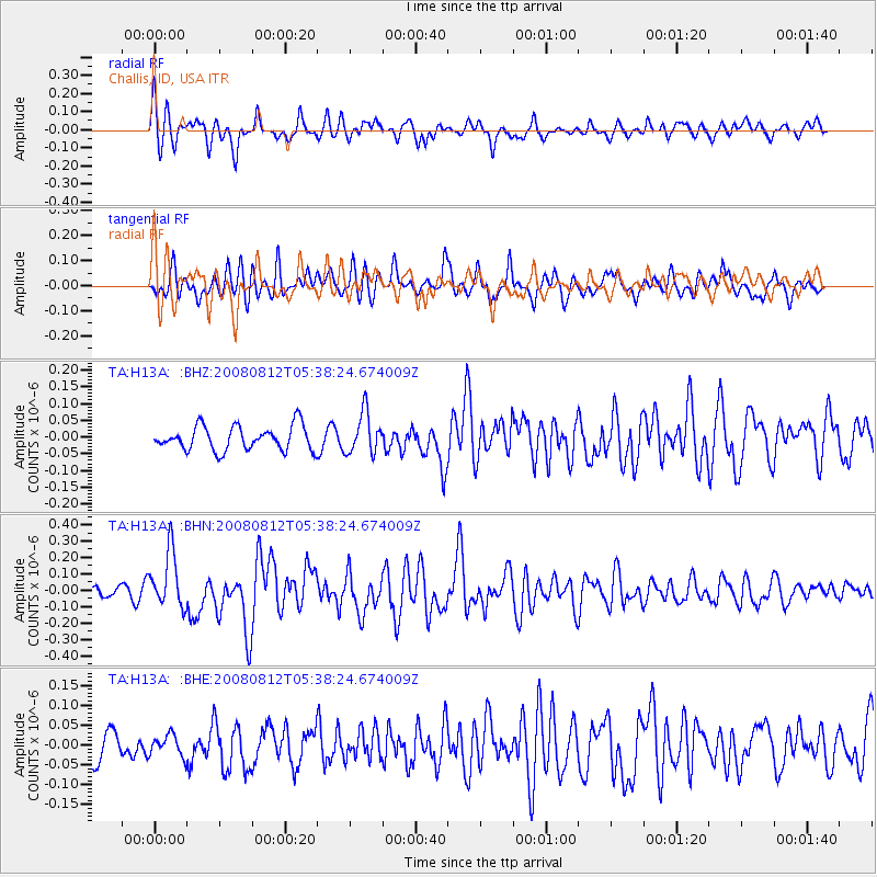
H13A Challis, ID, USA - Earthquake Result Viewer
*The percent match for this event was below the threshold and hence no stack was calculated.
| Earthquake location: |
Santa Cruz Islands |
| Earthquake latitude/longitude: |
-11.4/166.2 |
| Earthquake time(UTC): |
2008/08/12 (225) 05:25:57 GMT |
| Earthquake Depth: |
38 km |
| Earthquake Magnitude: |
5.9 MW, 5.4 MS, 5.2 MB, 5.8 MW |
| Earthquake Catalog/Contributor: |
WHDF/NEIC |
|
| Network: |
TA USArray Transportable Network (new EarthScope stations) |
| Station: |
H13A Challis, ID, USA |
| Lat/Lon: |
44.56 N/114.25 W |
| Elevation: |
1563 m |
|
| Distance: |
90.6 deg |
| Az: |
44.662 deg |
| Baz: |
254.601 deg |
| Ray Param: |
$rayparam |
*The percent match for this event was below the threshold and hence was not used in the summary stack. |
|
| Radial Match: |
73.834206 % |
| Radial Bump: |
400 |
| Transverse Match: |
61.437878 % |
| Transverse Bump: |
400 |
| SOD ConfigId: |
2504 |
| Insert Time: |
2010-03-06 14:08:36.632 +0000 |
| GWidth: |
2.5 |
| Max Bumps: |
400 |
| Tol: |
0.001 |
|
Signal To Noise
| Channel | StoN | STA | LTA |
| TA:H13A: :BHN:20080812T05:38:24.674009Z | 5.230208 | 1.7197333E-7 | 3.288078E-8 |
| TA:H13A: :BHE:20080812T05:38:24.674009Z | 0.4662224 | 2.6280745E-8 | 5.6369544E-8 |
| TA:H13A: :BHZ:20080812T05:38:24.674009Z | 1.6917572 | 6.110133E-8 | 3.611708E-8 |
| Arrivals |
| Ps | |
| PpPs | |
| PsPs/PpSs | |


