You are here: Home > Network List > TA - USArray Transportable Network (new EarthScope stations) Stations List
> Station H13A Challis, ID, USA > Earthquake Result Viewer
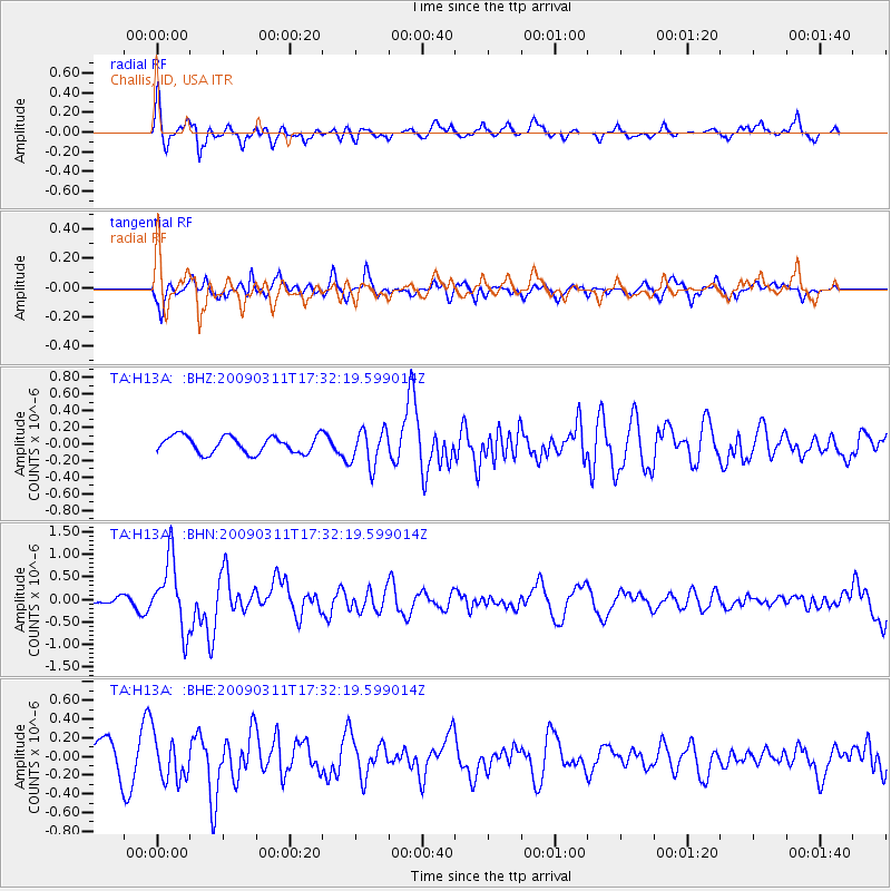
H13A Challis, ID, USA - Earthquake Result Viewer
*The percent match for this event was below the threshold and hence no stack was calculated.
| Earthquake location: |
Costa Rica |
| Earthquake latitude/longitude: |
8.5/-83.2 |
| Earthquake time(UTC): |
2009/03/11 (070) 17:24:36 GMT |
| Earthquake Depth: |
14 km |
| Earthquake Magnitude: |
5.8 MB, 5.6 MS, 5.9 MW, 5.9 MW |
| Earthquake Catalog/Contributor: |
WHDF/NEIC |
|
| Network: |
TA USArray Transportable Network (new EarthScope stations) |
| Station: |
H13A Challis, ID, USA |
| Lat/Lon: |
44.56 N/114.25 W |
| Elevation: |
1563 m |
|
| Distance: |
44.9 deg |
| Az: |
328.515 deg |
| Baz: |
133.72 deg |
| Ray Param: |
$rayparam |
*The percent match for this event was below the threshold and hence was not used in the summary stack. |
|
| Radial Match: |
69.98326 % |
| Radial Bump: |
400 |
| Transverse Match: |
69.52478 % |
| Transverse Bump: |
400 |
| SOD ConfigId: |
2658 |
| Insert Time: |
2010-03-06 14:09:06.383 +0000 |
| GWidth: |
2.5 |
| Max Bumps: |
400 |
| Tol: |
0.001 |
|
Signal To Noise
| Channel | StoN | STA | LTA |
| TA:H13A: :BHN:20090311T17:32:19.599014Z | 10.422159 | 7.690713E-7 | 7.379193E-8 |
| TA:H13A: :BHE:20090311T17:32:19.599014Z | 1.8730768 | 2.3267441E-7 | 1.2422043E-7 |
| TA:H13A: :BHZ:20090311T17:32:19.599014Z | 2.1280158 | 2.1785094E-7 | 1.023728E-7 |
| Arrivals |
| Ps | |
| PpPs | |
| PsPs/PpSs | |


