You are here: Home > Network List > II - Global Seismograph Network (GSN - IRIS/IDA) Stations List
> Station WRAB Tennant Creek, NT, Australia > Earthquake Result Viewer
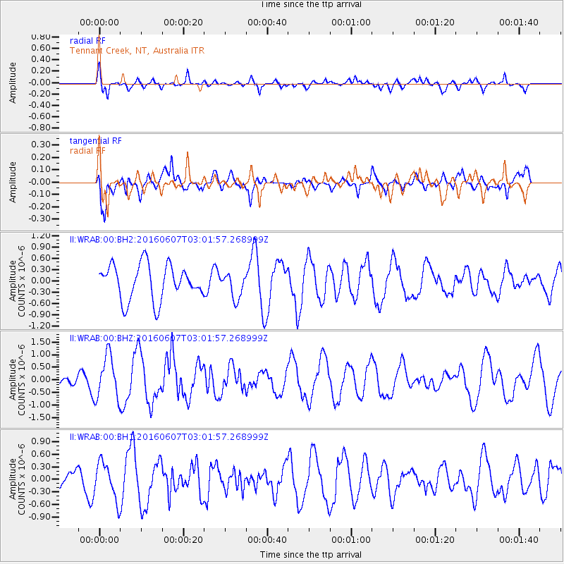
WRAB Tennant Creek, NT, Australia - Earthquake Result Viewer
*The percent match for this event was below the threshold and hence no stack was calculated.
| Earthquake location: |
Off W. Coast Of S. Island, N.Z. |
| Earthquake latitude/longitude: |
-45.2/166.8 |
| Earthquake time(UTC): |
2016/06/07 (159) 02:55:23 GMT |
| Earthquake Depth: |
40 km |
| Earthquake Magnitude: |
5.5 MWW, 5.4 MWR |
| Earthquake Catalog/Contributor: |
NEIC PDE/NEIC COMCAT |
|
| Network: |
II Global Seismograph Network (GSN - IRIS/IDA) |
| Station: |
WRAB Tennant Creek, NT, Australia |
| Lat/Lon: |
19.93 S/134.36 E |
| Elevation: |
366 m |
|
| Distance: |
36.8 deg |
| Az: |
302.444 deg |
| Baz: |
140.601 deg |
| Ray Param: |
$rayparam |
*The percent match for this event was below the threshold and hence was not used in the summary stack. |
|
| Radial Match: |
63.678158 % |
| Radial Bump: |
400 |
| Transverse Match: |
59.81674 % |
| Transverse Bump: |
400 |
| SOD ConfigId: |
1634031 |
| Insert Time: |
2016-07-03 22:43:47.532 +0000 |
| GWidth: |
2.5 |
| Max Bumps: |
400 |
| Tol: |
0.001 |
|
Signal To Noise
| Channel | StoN | STA | LTA |
| II:WRAB:00:BHZ:20160607T03:01:57.268999Z | 2.3605366 | 8.6191443E-7 | 3.6513495E-7 |
| II:WRAB:00:BH1:20160607T03:01:57.268999Z | 1.2862594 | 4.5841855E-7 | 3.5639664E-7 |
| II:WRAB:00:BH2:20160607T03:01:57.268999Z | 0.73636127 | 3.4561307E-7 | 4.6935259E-7 |
| Arrivals |
| Ps | |
| PpPs | |
| PsPs/PpSs | |


