You are here: Home > Network List > TA - USArray Transportable Network (new EarthScope stations) Stations List
> Station C23K Itkillik River, AK, USA > Earthquake Result Viewer
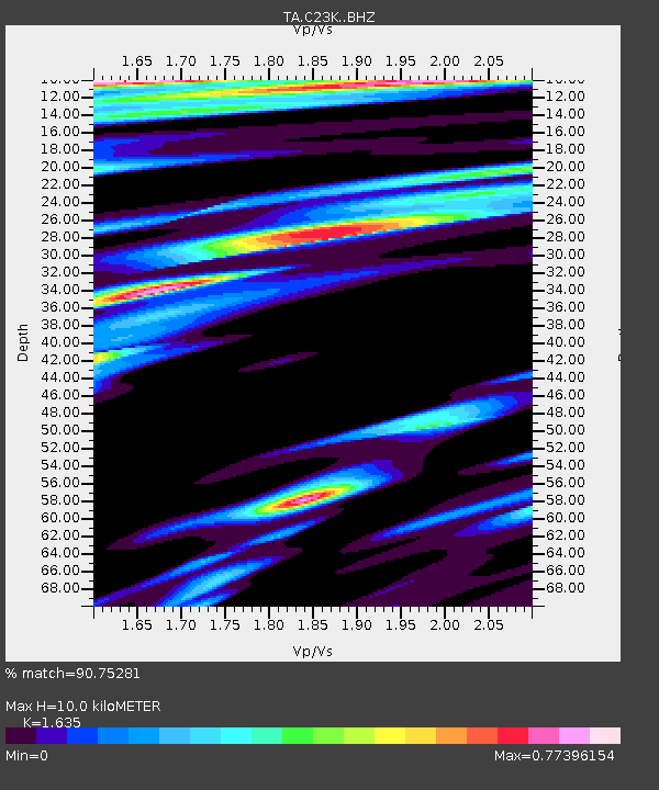
C23K Itkillik River, AK, USA - Earthquake Result Viewer
| Earthquake location: |
Costa Rica |
| Earthquake latitude/longitude: |
8.8/-83.2 |
| Earthquake time(UTC): |
2018/08/17 (229) 23:22:24 GMT |
| Earthquake Depth: |
15 km |
| Earthquake Magnitude: |
6.1 Mww |
| Earthquake Catalog/Contributor: |
NEIC PDE/us |
|
| Network: |
TA USArray Transportable Network (new EarthScope stations) |
| Station: |
C23K Itkillik River, AK, USA |
| Lat/Lon: |
69.84 N/150.61 W |
| Elevation: |
179 m |
|
| Distance: |
74.1 deg |
| Az: |
340.552 deg |
| Baz: |
108.354 deg |
| Ray Param: |
0.052530773 |
| Estimated Moho Depth: |
10.0 km |
| Estimated Crust Vp/Vs: |
1.63 |
| Assumed Crust Vp: |
6.221 km/s |
| Estimated Crust Vs: |
3.805 km/s |
| Estimated Crust Poisson's Ratio: |
0.20 |
|
| Radial Match: |
90.75281 % |
| Radial Bump: |
400 |
| Transverse Match: |
92.68288 % |
| Transverse Bump: |
400 |
| SOD ConfigId: |
13570011 |
| Insert Time: |
2019-04-30 20:37:17.370 +0000 |
| GWidth: |
2.5 |
| Max Bumps: |
400 |
| Tol: |
0.001 |
|

Signal To Noise
| Channel | StoN | STA | LTA |
| TA:C23K: :BHZ:20180817T23:33:29.199988Z | 23.65706 | 2.6014307E-6 | 1.0996424E-7 |
| TA:C23K: :BHN:20180817T23:33:29.199988Z | 8.466474 | 6.385729E-7 | 7.542371E-8 |
| TA:C23K: :BHE:20180817T23:33:29.199988Z | 6.7426486 | 5.272822E-7 | 7.8201055E-8 |
| Arrivals |
| Ps | 1.1 SECOND |
| PpPs | 4.1 SECOND |
| PsPs/PpSs | 5.2 SECOND |


