You are here: Home > Network List > TA - USArray Transportable Network (new EarthScope stations) Stations List
> Station H13A Challis, ID, USA > Earthquake Result Viewer
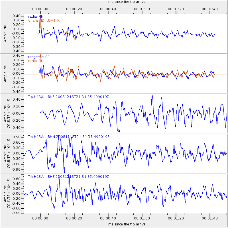
H13A Challis, ID, USA - Earthquake Result Viewer
*The percent match for this event was below the threshold and hence no stack was calculated.
| Earthquake location: |
Near Coast Of Central Chile |
| Earthquake latitude/longitude: |
-32.5/-71.7 |
| Earthquake time(UTC): |
2008/12/18 (353) 21:19:28 GMT |
| Earthquake Depth: |
18 km |
| Earthquake Magnitude: |
5.8 MB, 6.0 MS, 6.2 MW, 6.1 MW |
| Earthquake Catalog/Contributor: |
WHDF/NEIC |
|
| Network: |
TA USArray Transportable Network (new EarthScope stations) |
| Station: |
H13A Challis, ID, USA |
| Lat/Lon: |
44.56 N/114.25 W |
| Elevation: |
1563 m |
|
| Distance: |
85.9 deg |
| Az: |
331.024 deg |
| Baz: |
145.044 deg |
| Ray Param: |
$rayparam |
*The percent match for this event was below the threshold and hence was not used in the summary stack. |
|
| Radial Match: |
64.48629 % |
| Radial Bump: |
400 |
| Transverse Match: |
55.76956 % |
| Transverse Bump: |
400 |
| SOD ConfigId: |
2658 |
| Insert Time: |
2010-03-06 14:09:11.937 +0000 |
| GWidth: |
2.5 |
| Max Bumps: |
400 |
| Tol: |
0.001 |
|
Signal To Noise
| Channel | StoN | STA | LTA |
| TA:H13A: :BHN:20081218T21:31:35.499019Z | 2.6760745 | 4.1541384E-7 | 1.5523253E-7 |
| TA:H13A: :BHE:20081218T21:31:35.499019Z | 0.9577856 | 1.0998181E-7 | 1.14829255E-7 |
| TA:H13A: :BHZ:20081218T21:31:35.499019Z | 0.9317056 | 1.3055268E-7 | 1.4012225E-7 |
| Arrivals |
| Ps | |
| PpPs | |
| PsPs/PpSs | |


