You are here: Home > Network List > TA - USArray Transportable Network (new EarthScope stations) Stations List
> Station G17K Kiwalik Mountain, AK, USA > Earthquake Result Viewer
G17K Kiwalik Mountain, AK, USA - Earthquake Result Viewer
| Earthquake location: |
Costa Rica |
| Earthquake latitude/longitude: |
8.8/-83.2 |
| Earthquake time(UTC): |
2018/08/17 (229) 23:22:24 GMT |
| Earthquake Depth: |
15 km |
| Earthquake Magnitude: |
6.1 Mww |
| Earthquake Catalog/Contributor: |
NEIC PDE/us |
|
| Network: |
TA USArray Transportable Network (new EarthScope stations) |
| Station: |
G17K Kiwalik Mountain, AK, USA |
| Lat/Lon: |
65.50 N/160.65 W |
| Elevation: |
338 m |
|
| Distance: |
76.9 deg |
| Az: |
335.292 deg |
| Baz: |
97.749 deg |
| Ray Param: |
0.050683916 |
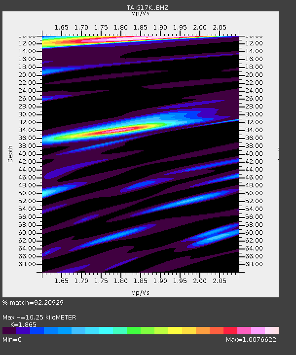
| Estimated Moho Depth: |
10.25 km |
| Estimated Crust Vp/Vs: |
1.87 |
| Assumed Crust Vp: |
6.276 km/s |
| Estimated Crust Vs: |
3.365 km/s |
| Estimated Crust Poisson's Ratio: |
0.30 |
|
| Radial Match: |
92.20929 % |
| Radial Bump: |
400 |
| Transverse Match: |
76.597046 % |
| Transverse Bump: |
400 |
| SOD ConfigId: |
13570011 |
| Insert Time: |
2019-04-30 20:37:50.330 +0000 |
| GWidth: |
2.5 |
| Max Bumps: |
400 |
| Tol: |
0.001 |
|

Signal To Noise
| Channel | StoN | STA | LTA |
| TA:G17K: :BHZ:20180817T23:33:44.949988Z | 19.958939 | 1.6085055E-6 | 8.059073E-8 |
| TA:G17K: :BHN:20180817T23:33:44.949988Z | 1.5832871 | 1.11371584E-7 | 7.0342004E-8 |
| TA:G17K: :BHE:20180817T23:33:44.949988Z | 8.118222 | 5.930553E-7 | 7.305236E-8 |
| Arrivals |
| Ps | 1.5 SECOND |
| PpPs | 4.5 SECOND |
| PsPs/PpSs | 6.0 SECOND |


