You are here: Home > Network List > TA - USArray Transportable Network (new EarthScope stations) Stations List
> Station H13A Challis, ID, USA > Earthquake Result Viewer
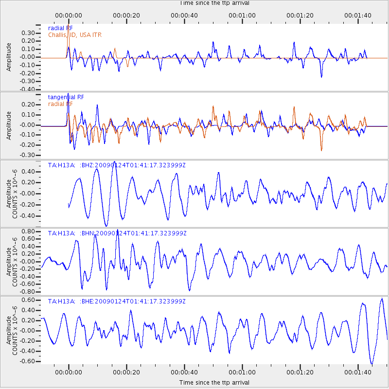
H13A Challis, ID, USA - Earthquake Result Viewer
*The percent match for this event was below the threshold and hence no stack was calculated.
| Earthquake location: |
Kermadec Islands Region |
| Earthquake latitude/longitude: |
-28.2/-176.7 |
| Earthquake time(UTC): |
2009/01/24 (024) 01:28:39 GMT |
| Earthquake Depth: |
10 km |
| Earthquake Magnitude: |
5.5 MB, 5.8 MS, 6.0 MW, 5.8 MW |
| Earthquake Catalog/Contributor: |
WHDF/NEIC |
|
| Network: |
TA USArray Transportable Network (new EarthScope stations) |
| Station: |
H13A Challis, ID, USA |
| Lat/Lon: |
44.56 N/114.25 W |
| Elevation: |
1563 m |
|
| Distance: |
92.2 deg |
| Az: |
39.358 deg |
| Baz: |
231.506 deg |
| Ray Param: |
$rayparam |
*The percent match for this event was below the threshold and hence was not used in the summary stack. |
|
| Radial Match: |
65.28883 % |
| Radial Bump: |
307 |
| Transverse Match: |
54.972996 % |
| Transverse Bump: |
378 |
| SOD ConfigId: |
2658 |
| Insert Time: |
2010-03-06 14:09:21.674 +0000 |
| GWidth: |
2.5 |
| Max Bumps: |
400 |
| Tol: |
0.001 |
|
Signal To Noise
| Channel | StoN | STA | LTA |
| TA:H13A: :BHN:20090124T01:41:17.323999Z | 2.2449186 | 3.7822682E-7 | 1.6848131E-7 |
| TA:H13A: :BHE:20090124T01:41:17.323999Z | 1.0160071 | 2.0244468E-7 | 1.9925518E-7 |
| TA:H13A: :BHZ:20090124T01:41:17.323999Z | 0.7905614 | 2.3926788E-7 | 3.0265568E-7 |
| Arrivals |
| Ps | |
| PpPs | |
| PsPs/PpSs | |


