You are here: Home > Network List > TA - USArray Transportable Network (new EarthScope stations) Stations List
> Station H23K Yukon River, AK, USA > Earthquake Result Viewer
H23K Yukon River, AK, USA - Earthquake Result Viewer
| Earthquake location: |
Costa Rica |
| Earthquake latitude/longitude: |
8.8/-83.2 |
| Earthquake time(UTC): |
2018/08/17 (229) 23:22:24 GMT |
| Earthquake Depth: |
15 km |
| Earthquake Magnitude: |
6.1 Mww |
| Earthquake Catalog/Contributor: |
NEIC PDE/us |
|
| Network: |
TA USArray Transportable Network (new EarthScope stations) |
| Station: |
H23K Yukon River, AK, USA |
| Lat/Lon: |
65.83 N/149.54 W |
| Elevation: |
617 m |
|
| Distance: |
72.5 deg |
| Az: |
336.69 deg |
| Baz: |
108.234 deg |
| Ray Param: |
0.053623382 |
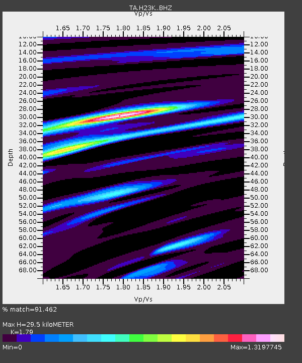
| Estimated Moho Depth: |
29.5 km |
| Estimated Crust Vp/Vs: |
1.79 |
| Assumed Crust Vp: |
6.566 km/s |
| Estimated Crust Vs: |
3.668 km/s |
| Estimated Crust Poisson's Ratio: |
0.27 |
|
| Radial Match: |
91.462 % |
| Radial Bump: |
400 |
| Transverse Match: |
83.66201 % |
| Transverse Bump: |
400 |
| SOD ConfigId: |
13570011 |
| Insert Time: |
2019-04-30 20:38:03.769 +0000 |
| GWidth: |
2.5 |
| Max Bumps: |
400 |
| Tol: |
0.001 |
|

Signal To Noise
| Channel | StoN | STA | LTA |
| TA:H23K: :BHZ:20180817T23:33:19.475012Z | 28.75967 | 1.497408E-6 | 5.2066245E-8 |
| TA:H23K: :BHN:20180817T23:33:19.475012Z | 5.633636 | 2.958097E-7 | 5.250778E-8 |
| TA:H23K: :BHE:20180817T23:33:19.475012Z | 10.181131 | 5.688774E-7 | 5.5875653E-8 |
| Arrivals |
| Ps | 3.7 SECOND |
| PpPs | 12 SECOND |
| PsPs/PpSs | 16 SECOND |


