You are here: Home > Network List > TA - USArray Transportable Network (new EarthScope stations) Stations List
> Station J14K Nanvaranak Lake, AK, USA > Earthquake Result Viewer
J14K Nanvaranak Lake, AK, USA - Earthquake Result Viewer
| Earthquake location: |
Costa Rica |
| Earthquake latitude/longitude: |
8.8/-83.2 |
| Earthquake time(UTC): |
2018/08/17 (229) 23:22:24 GMT |
| Earthquake Depth: |
15 km |
| Earthquake Magnitude: |
6.1 Mww |
| Earthquake Catalog/Contributor: |
NEIC PDE/us |
|
| Network: |
TA USArray Transportable Network (new EarthScope stations) |
| Station: |
J14K Nanvaranak Lake, AK, USA |
| Lat/Lon: |
62.75 N/163.55 W |
| Elevation: |
25 m |
|
| Distance: |
77.9 deg |
| Az: |
332.338 deg |
| Baz: |
94.494 deg |
| Ray Param: |
0.050027218 |
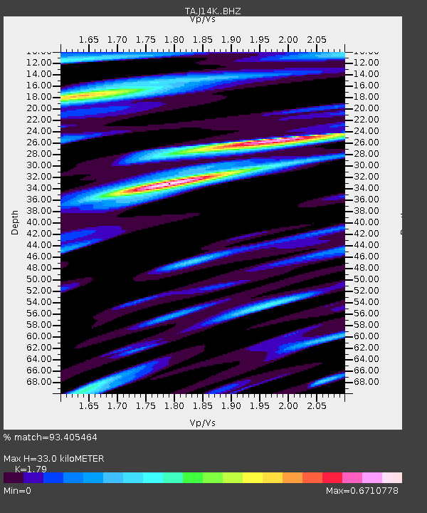
| Estimated Moho Depth: |
33.0 km |
| Estimated Crust Vp/Vs: |
1.79 |
| Assumed Crust Vp: |
6.155 km/s |
| Estimated Crust Vs: |
3.438 km/s |
| Estimated Crust Poisson's Ratio: |
0.27 |
|
| Radial Match: |
93.405464 % |
| Radial Bump: |
400 |
| Transverse Match: |
89.18698 % |
| Transverse Bump: |
400 |
| SOD ConfigId: |
13570011 |
| Insert Time: |
2019-04-30 20:38:14.612 +0000 |
| GWidth: |
2.5 |
| Max Bumps: |
400 |
| Tol: |
0.001 |
|

Signal To Noise
| Channel | StoN | STA | LTA |
| TA:J14K: :BHZ:20180817T23:33:50.400Z | 21.706575 | 2.255373E-6 | 1.0390275E-7 |
| TA:J14K: :BHN:20180817T23:33:50.400Z | 6.15106 | 4.607277E-7 | 7.490216E-8 |
| TA:J14K: :BHE:20180817T23:33:50.400Z | 6.2885756 | 6.8064304E-7 | 1.0823485E-7 |
| Arrivals |
| Ps | 4.4 SECOND |
| PpPs | 15 SECOND |
| PsPs/PpSs | 19 SECOND |


