You are here: Home > Network List > TA - USArray Transportable Network (new EarthScope stations) Stations List
> Station M17K Holitna River, AK, USA > Earthquake Result Viewer
M17K Holitna River, AK, USA - Earthquake Result Viewer
| Earthquake location: |
Costa Rica |
| Earthquake latitude/longitude: |
8.8/-83.2 |
| Earthquake time(UTC): |
2018/08/17 (229) 23:22:24 GMT |
| Earthquake Depth: |
15 km |
| Earthquake Magnitude: |
6.1 Mww |
| Earthquake Catalog/Contributor: |
NEIC PDE/us |
|
| Network: |
TA USArray Transportable Network (new EarthScope stations) |
| Station: |
M17K Holitna River, AK, USA |
| Lat/Lon: |
61.40 N/157.44 W |
| Elevation: |
387 m |
|
| Distance: |
74.8 deg |
| Az: |
331.322 deg |
| Baz: |
99.652 deg |
| Ray Param: |
0.052056998 |
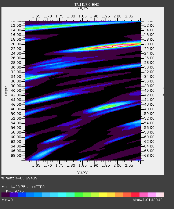
| Estimated Moho Depth: |
20.75 km |
| Estimated Crust Vp/Vs: |
1.98 |
| Assumed Crust Vp: |
6.155 km/s |
| Estimated Crust Vs: |
3.112 km/s |
| Estimated Crust Poisson's Ratio: |
0.33 |
|
| Radial Match: |
85.69409 % |
| Radial Bump: |
400 |
| Transverse Match: |
75.41461 % |
| Transverse Bump: |
400 |
| SOD ConfigId: |
13570011 |
| Insert Time: |
2019-04-30 20:38:39.957 +0000 |
| GWidth: |
2.5 |
| Max Bumps: |
400 |
| Tol: |
0.001 |
|

Signal To Noise
| Channel | StoN | STA | LTA |
| TA:M17K: :BHZ:20180817T23:33:33.275Z | 12.408161 | 1.1991335E-6 | 9.664071E-8 |
| TA:M17K: :BHN:20180817T23:33:33.275Z | 2.7370183 | 2.3753574E-7 | 8.6786315E-8 |
| TA:M17K: :BHE:20180817T23:33:33.275Z | 7.575722 | 6.202572E-7 | 8.187433E-8 |
| Arrivals |
| Ps | 3.4 SECOND |
| PpPs | 9.8 SECOND |
| PsPs/PpSs | 13 SECOND |


