You are here: Home > Network List > TA - USArray Transportable Network (new EarthScope stations) Stations List
> Station H13A Challis, ID, USA > Earthquake Result Viewer
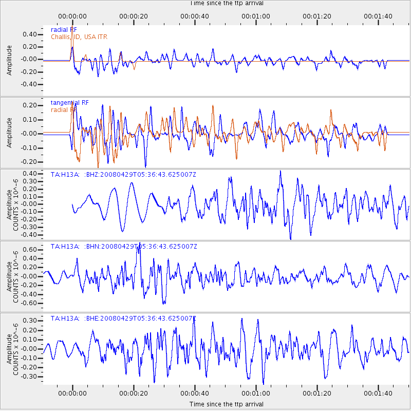
H13A Challis, ID, USA - Earthquake Result Viewer
*The percent match for this event was below the threshold and hence no stack was calculated.
| Earthquake location: |
Hokkaido, Japan Region |
| Earthquake latitude/longitude: |
41.5/142.0 |
| Earthquake time(UTC): |
2008/04/29 (120) 05:26:04 GMT |
| Earthquake Depth: |
47 km |
| Earthquake Magnitude: |
5.5 MB, 5.2 MS, 5.8 MW, 5.8 MW |
| Earthquake Catalog/Contributor: |
WHDF/NEIC |
|
| Network: |
TA USArray Transportable Network (new EarthScope stations) |
| Station: |
H13A Challis, ID, USA |
| Lat/Lon: |
44.56 N/114.25 W |
| Elevation: |
1563 m |
|
| Distance: |
70.5 deg |
| Az: |
47.45 deg |
| Baz: |
309.221 deg |
| Ray Param: |
$rayparam |
*The percent match for this event was below the threshold and hence was not used in the summary stack. |
|
| Radial Match: |
49.68834 % |
| Radial Bump: |
400 |
| Transverse Match: |
69.219894 % |
| Transverse Bump: |
400 |
| SOD ConfigId: |
2504 |
| Insert Time: |
2010-03-06 14:09:35.689 +0000 |
| GWidth: |
2.5 |
| Max Bumps: |
400 |
| Tol: |
0.001 |
|
Signal To Noise
| Channel | StoN | STA | LTA |
| TA:H13A: :BHN:20080429T05:36:43.625007Z | 2.4507782 | 1.8277349E-7 | 7.4577734E-8 |
| TA:H13A: :BHE:20080429T05:36:43.625007Z | 0.7649566 | 6.723413E-8 | 8.7892744E-8 |
| TA:H13A: :BHZ:20080429T05:36:43.625007Z | 0.3812901 | 5.6779648E-8 | 1.4891455E-7 |
| Arrivals |
| Ps | |
| PpPs | |
| PsPs/PpSs | |


