You are here: Home > Network List > TA - USArray Transportable Network (new EarthScope stations) Stations List
> Station H13A Challis, ID, USA > Earthquake Result Viewer
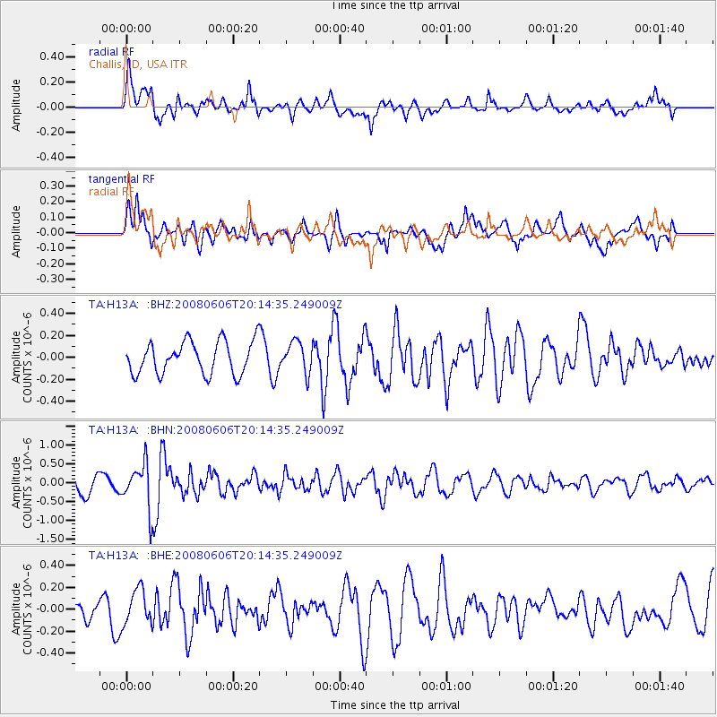
H13A Challis, ID, USA - Earthquake Result Viewer
*The percent match for this event was below the threshold and hence no stack was calculated.
| Earthquake location: |
Northern Algeria |
| Earthquake latitude/longitude: |
35.9/-0.7 |
| Earthquake time(UTC): |
2008/06/06 (158) 20:02:56 GMT |
| Earthquake Depth: |
4.0 km |
| Earthquake Magnitude: |
5.5 MB, 5.3 MS, 5.5 MW, 5.5 MW |
| Earthquake Catalog/Contributor: |
WHDF/NEIC |
|
| Network: |
TA USArray Transportable Network (new EarthScope stations) |
| Station: |
H13A Challis, ID, USA |
| Lat/Lon: |
44.56 N/114.25 W |
| Elevation: |
1563 m |
|
| Distance: |
79.9 deg |
| Az: |
318.287 deg |
| Baz: |
49.108 deg |
| Ray Param: |
$rayparam |
*The percent match for this event was below the threshold and hence was not used in the summary stack. |
|
| Radial Match: |
65.71588 % |
| Radial Bump: |
400 |
| Transverse Match: |
60.58061 % |
| Transverse Bump: |
400 |
| SOD ConfigId: |
2504 |
| Insert Time: |
2010-03-06 14:09:37.679 +0000 |
| GWidth: |
2.5 |
| Max Bumps: |
400 |
| Tol: |
0.001 |
|
Signal To Noise
| Channel | StoN | STA | LTA |
| TA:H13A: :BHN:20080606T20:14:35.249009Z | 2.5916474 | 5.9558204E-7 | 2.2980828E-7 |
| TA:H13A: :BHE:20080606T20:14:35.249009Z | 0.7606234 | 1.6227364E-7 | 2.1334296E-7 |
| TA:H13A: :BHZ:20080606T20:14:35.249009Z | 0.9454851 | 1.3952352E-7 | 1.4756817E-7 |
| Arrivals |
| Ps | |
| PpPs | |
| PsPs/PpSs | |


