You are here: Home > Network List > TA - USArray Transportable Network (new EarthScope stations) Stations List
> Station T25A Trinidad, CO, USA > Earthquake Result Viewer
T25A Trinidad, CO, USA - Earthquake Result Viewer
| Earthquake location: |
Costa Rica |
| Earthquake latitude/longitude: |
8.8/-83.2 |
| Earthquake time(UTC): |
2018/08/17 (229) 23:22:24 GMT |
| Earthquake Depth: |
15 km |
| Earthquake Magnitude: |
6.1 Mww |
| Earthquake Catalog/Contributor: |
NEIC PDE/us |
|
| Network: |
TA USArray Transportable Network (new EarthScope stations) |
| Station: |
T25A Trinidad, CO, USA |
| Lat/Lon: |
37.14 N/104.41 W |
| Elevation: |
2017 m |
|
| Distance: |
34.2 deg |
| Az: |
328.96 deg |
| Baz: |
140.371 deg |
| Ray Param: |
0.077852234 |
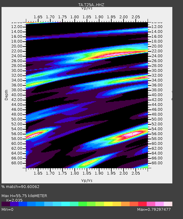
| Estimated Moho Depth: |
55.75 km |
| Estimated Crust Vp/Vs: |
2.04 |
| Assumed Crust Vp: |
6.316 km/s |
| Estimated Crust Vs: |
3.103 km/s |
| Estimated Crust Poisson's Ratio: |
0.34 |
|
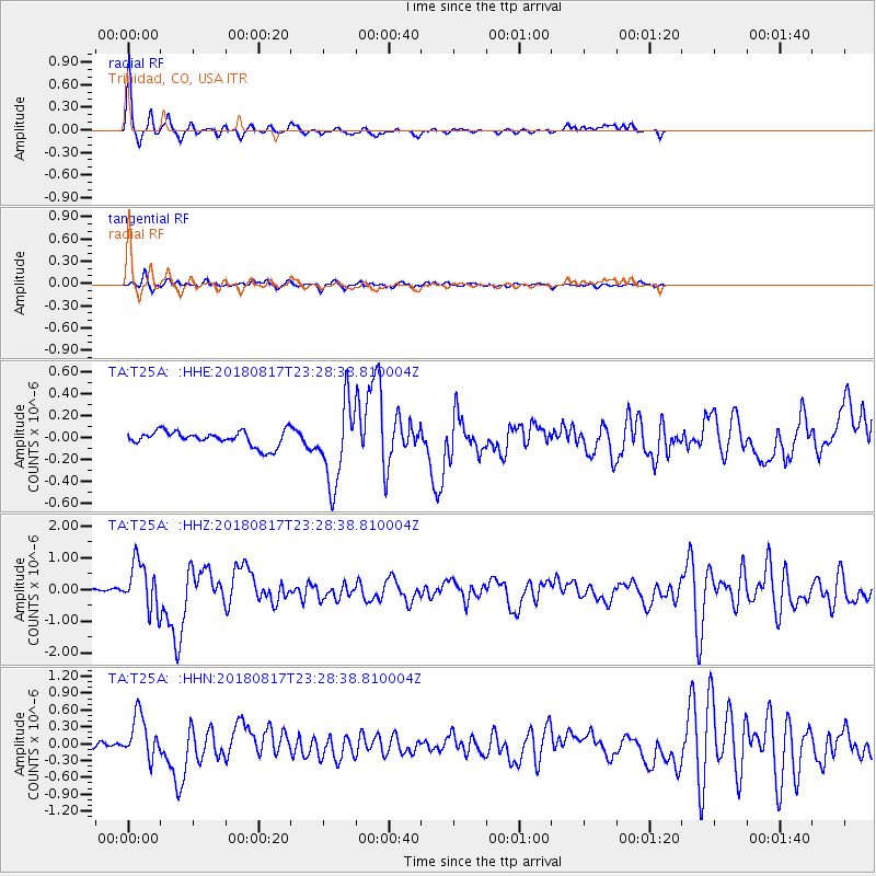
| Radial Match: |
90.60062 % |
| Radial Bump: |
238 |
| Transverse Match: |
62.826206 % |
| Transverse Bump: |
400 |
| SOD ConfigId: |
13570011 |
| Insert Time: |
2019-04-30 20:39:31.170 +0000 |
| GWidth: |
2.5 |
| Max Bumps: |
400 |
| Tol: |
0.001 |
|
Signal To Noise
| Channel | StoN | STA | LTA |
| TA:T25A: :HHZ:20180817T23:28:38.810004Z | 9.583056 | 7.312032E-7 | 7.630167E-8 |
| TA:T25A: :HHN:20180817T23:28:38.810004Z | 5.419016 | 3.8561168E-7 | 7.1158986E-8 |
| TA:T25A: :HHE:20180817T23:28:38.810004Z | 5.276065 | 3.588819E-7 | 6.8020746E-8 |
| Arrivals |
| Ps | 9.7 SECOND |
| PpPs | 25 SECOND |
| PsPs/PpSs | 35 SECOND |


