You are here: Home > Network List > TA - USArray Transportable Network (new EarthScope stations) Stations List
> Station H13A Challis, ID, USA > Earthquake Result Viewer
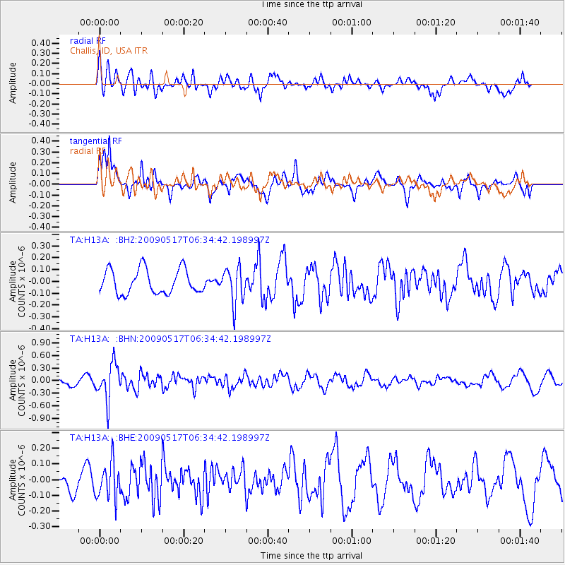
H13A Challis, ID, USA - Earthquake Result Viewer
*The percent match for this event was below the threshold and hence no stack was calculated.
| Earthquake location: |
Tonga Islands |
| Earthquake latitude/longitude: |
-16.8/-173.5 |
| Earthquake time(UTC): |
2009/05/17 (137) 06:23:03 GMT |
| Earthquake Depth: |
67 km |
| Earthquake Magnitude: |
5.5 MB, 5.6 MW, 5.6 MW |
| Earthquake Catalog/Contributor: |
WHDF/NEIC |
|
| Network: |
TA USArray Transportable Network (new EarthScope stations) |
| Station: |
H13A Challis, ID, USA |
| Lat/Lon: |
44.56 N/114.25 W |
| Elevation: |
1563 m |
|
| Distance: |
81.4 deg |
| Az: |
38.401 deg |
| Baz: |
236.331 deg |
| Ray Param: |
$rayparam |
*The percent match for this event was below the threshold and hence was not used in the summary stack. |
|
| Radial Match: |
50.401844 % |
| Radial Bump: |
400 |
| Transverse Match: |
72.127426 % |
| Transverse Bump: |
400 |
| SOD ConfigId: |
2760 |
| Insert Time: |
2010-03-06 14:09:56.597 +0000 |
| GWidth: |
2.5 |
| Max Bumps: |
400 |
| Tol: |
0.001 |
|
Signal To Noise
| Channel | StoN | STA | LTA |
| TA:H13A: :BHN:20090517T06:34:42.198997Z | 2.9274402 | 4.4234147E-7 | 1.511018E-7 |
| TA:H13A: :BHE:20090517T06:34:42.198997Z | 0.83541006 | 1.17413826E-7 | 1.4054633E-7 |
| TA:H13A: :BHZ:20090517T06:34:42.198997Z | 1.4707273 | 1.5185296E-7 | 1.03250244E-7 |
| Arrivals |
| Ps | |
| PpPs | |
| PsPs/PpSs | |


