F13A Darby, MT, USA - Earthquake Result Viewer
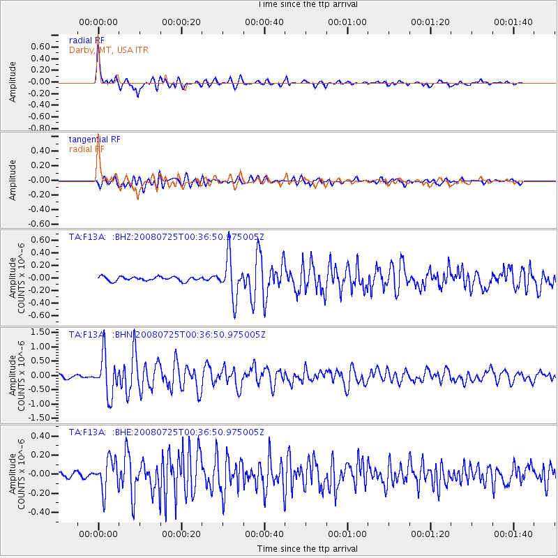
Earthquake location: Rat Islands, Aleutian Islands
Earthquake latitude/longitude: 51.3/179.0
Earthquake time(UTC): 2008/07/25 (207) 00:29:22 GMT
Earthquake Depth: 21 km
Earthquake Magnitude: 5.7 MB, 5.5 MS, 5.9 MW, 5.9 MW
Earthquake Catalog/Contributor: WHDF/NEIC
Network: TA USArray Transportable Network (new EarthScope stations)
Station: F13A Darby, MT, USA
Lat/Lon: 45.79 N/114.33 W
Elevation: 1462 m
Distance: 43.1 deg
Az: 70.05 deg
Baz: 302.459 deg
Ray Param: 0.07272338
Estimated Moho Depth: 34.0 km
Estimated Crust Vp/Vs: 1.75
Assumed Crust Vp: 6.577 km/s
Estimated Crust Vs: 3.753 km/s
Estimated Crust Poisson's Ratio: 0.26
Radial Match: 88.03517 %
Radial Bump: 400
Transverse Match: 84.23029 %
Transverse Bump: 400
SOD ConfigId: 2504
Insert Time: 2010-03-06 14:10:09.367 +0000
GWidth: 2.5
Max Bumps: 400
Tol: 0.001

Signal To Noise

ChannelStoNSTALTA
TA:F13A: :BHN:20080725T00:36:50.975005Z12.3556117.1033395E-75.7490805E-8
TA:F13A: :BHE:20080725T00:36:50.975005Z3.83555631.6853481E-74.394012E-8
TA:F13A: :BHZ:20080725T00:36:50.975005Z10.0582253.330411E-73.311132E-8
Arrivals
Ps4.2 SECOND
PpPs13 SECOND
PsPs/PpSs17 SECOND