You are here: Home > Network List > AV - Alaska Volcano Observatory Stations List
> Station MAPS Pakushin Southeast, Makushin Volcano, Alaska > Earthquake Result Viewer
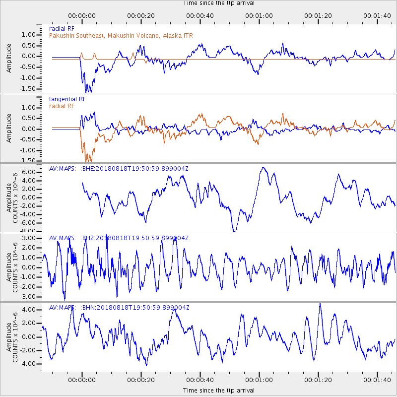
MAPS Pakushin Southeast, Makushin Volcano, Alaska - Earthquake Result Viewer
*The percent match for this event was below the threshold and hence no stack was calculated.
| Earthquake location: |
Panama-Colombia Border Region |
| Earthquake latitude/longitude: |
8.8/-77.3 |
| Earthquake time(UTC): |
2018/08/18 (230) 19:39:07 GMT |
| Earthquake Depth: |
10 km |
| Earthquake Magnitude: |
5.6 Mww |
| Earthquake Catalog/Contributor: |
NEIC PDE/us |
|
| Network: |
AV Alaska Volcano Observatory |
| Station: |
MAPS Pakushin Southeast, Makushin Volcano, Alaska |
| Lat/Lon: |
53.81 N/166.94 W |
| Elevation: |
333 m |
|
| Distance: |
82.7 deg |
| Az: |
323.283 deg |
| Baz: |
85.052 deg |
| Ray Param: |
$rayparam |
*The percent match for this event was below the threshold and hence was not used in the summary stack. |
|
| Radial Match: |
73.5059 % |
| Radial Bump: |
400 |
| Transverse Match: |
72.82682 % |
| Transverse Bump: |
400 |
| SOD ConfigId: |
13570011 |
| Insert Time: |
2019-04-30 20:43:18.581 +0000 |
| GWidth: |
2.5 |
| Max Bumps: |
400 |
| Tol: |
0.001 |
|
Signal To Noise
| Channel | StoN | STA | LTA |
| AV:MAPS: :BHZ:20180818T19:50:59.899004Z | 1.1451697 | 1.4079576E-6 | 1.2294752E-6 |
| AV:MAPS: :BHN:20180818T19:50:59.899004Z | 2.117736 | 2.7740352E-6 | 1.309906E-6 |
| AV:MAPS: :BHE:20180818T19:50:59.899004Z | 2.569498 | 5.24309E-6 | 2.0405114E-6 |
| Arrivals |
| Ps | |
| PpPs | |
| PsPs/PpSs | |


