You are here: Home > Network List > IW - Intermountain West Stations List
> Station MOOW Moose Ponds, Wyoming, USA > Earthquake Result Viewer
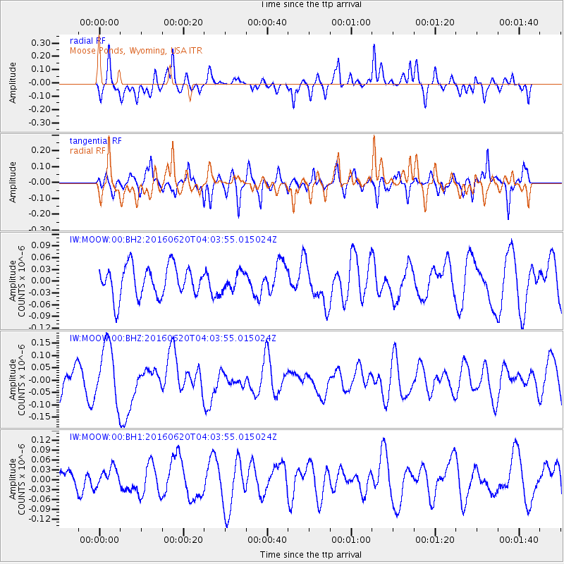
MOOW Moose Ponds, Wyoming, USA - Earthquake Result Viewer
*The percent match for this event was below the threshold and hence no stack was calculated.
| Earthquake location: |
Loyalty Islands |
| Earthquake latitude/longitude: |
-20.2/168.8 |
| Earthquake time(UTC): |
2016/06/20 (172) 03:50:55 GMT |
| Earthquake Depth: |
15 km |
| Earthquake Magnitude: |
6.0 MWW, 5.8 MWB, 5.9 MWC, 6.0 MWC |
| Earthquake Catalog/Contributor: |
NEIC PDE/NEIC COMCAT |
|
| Network: |
IW Intermountain West |
| Station: |
MOOW Moose Ponds, Wyoming, USA |
| Lat/Lon: |
43.75 N/110.74 W |
| Elevation: |
2128 m |
|
| Distance: |
97.1 deg |
| Az: |
46.082 deg |
| Baz: |
248.993 deg |
| Ray Param: |
$rayparam |
*The percent match for this event was below the threshold and hence was not used in the summary stack. |
|
| Radial Match: |
80.53959 % |
| Radial Bump: |
400 |
| Transverse Match: |
62.95251 % |
| Transverse Bump: |
378 |
| SOD ConfigId: |
1634031 |
| Insert Time: |
2016-07-04 03:52:15.881 +0000 |
| GWidth: |
2.5 |
| Max Bumps: |
400 |
| Tol: |
0.001 |
|
Signal To Noise
| Channel | StoN | STA | LTA |
| IW:MOOW:00:BHZ:20160620T04:03:55.015024Z | 1.6651849 | 1.2091456E-7 | 7.2613304E-8 |
| IW:MOOW:00:BH1:20160620T04:03:55.015024Z | 1.0603933 | 2.6844857E-8 | 2.5315941E-8 |
| IW:MOOW:00:BH2:20160620T04:03:55.015024Z | 0.57788885 | 2.2647017E-8 | 3.9189228E-8 |
| Arrivals |
| Ps | |
| PpPs | |
| PsPs/PpSs | |


