You are here: Home > Network List > TA - USArray Transportable Network (new EarthScope stations) Stations List
> Station F13A Darby, MT, USA > Earthquake Result Viewer
F13A Darby, MT, USA - Earthquake Result Viewer

| Earthquake location: |
Mariana Islands |
| Earthquake latitude/longitude: |
18.9/145.4 |
| Earthquake time(UTC): |
2007/10/31 (304) 03:30:17 GMT |
| Earthquake Depth: |
223 km |
| Earthquake Magnitude: |
6.2 MB, 7.2 MW, 7.2 MW |
| Earthquake Catalog/Contributor: |
WHDF/NEIC |
|
| Network: |
TA USArray Transportable Network (new EarthScope stations) |
| Station: |
F13A Darby, MT, USA |
| Lat/Lon: |
45.79 N/114.33 W |
| Elevation: |
1462 m |
|
| Distance: |
83.6 deg |
| Az: |
43.847 deg |
| Baz: |
290.39 deg |
| Ray Param: |
0.045530867 |
| Estimated Moho Depth: |
39.25 km |
| Estimated Crust Vp/Vs: |
1.72 |
| Assumed Crust Vp: |
6.577 km/s |
| Estimated Crust Vs: |
3.829 km/s |
| Estimated Crust Poisson's Ratio: |
0.24 |
|
| Radial Match: |
92.527534 % |
| Radial Bump: |
400 |
| Transverse Match: |
73.0495 % |
| Transverse Bump: |
400 |
| SOD ConfigId: |
2564 |
| Insert Time: |
2010-03-06 14:11:12.095 +0000 |
| GWidth: |
2.5 |
| Max Bumps: |
400 |
| Tol: |
0.001 |
|
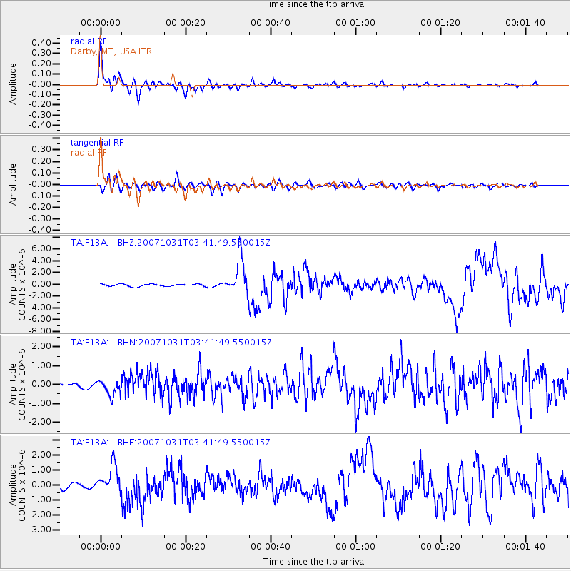
Signal To Noise
| Channel | StoN | STA | LTA |
| TA:F13A: :BHN:20071031T03:41:49.550015Z | 2.1127107 | 4.2968264E-7 | 2.0337978E-7 |
| TA:F13A: :BHE:20071031T03:41:49.550015Z | 4.6298785 | 9.581385E-7 | 2.0694678E-7 |
| TA:F13A: :BHZ:20071031T03:41:49.550015Z | 16.928823 | 3.2142736E-6 | 1.8986987E-7 |
| Arrivals |
| Ps | 4.4 SECOND |
| PpPs | 16 SECOND |
| PsPs/PpSs | 20 SECOND |


