You are here: Home > Network List > TA - USArray Transportable Network (new EarthScope stations) Stations List
> Station F13A Darby, MT, USA > Earthquake Result Viewer
F13A Darby, MT, USA - Earthquake Result Viewer
| Earthquake location: |
South Of Mariana Islands |
| Earthquake latitude/longitude: |
10.5/145.7 |
| Earthquake time(UTC): |
2007/09/30 (273) 02:08:30 GMT |
| Earthquake Depth: |
14 km |
| Earthquake Magnitude: |
6.4 MB, 7.1 MS, 6.9 MW, 6.9 MW |
| Earthquake Catalog/Contributor: |
WHDF/NEIC |
|
| Network: |
TA USArray Transportable Network (new EarthScope stations) |
| Station: |
F13A Darby, MT, USA |
| Lat/Lon: |
45.79 N/114.33 W |
| Elevation: |
1462 m |
|
| Distance: |
89.4 deg |
| Az: |
43.568 deg |
| Baz: |
284.334 deg |
| Ray Param: |
0.041846 |
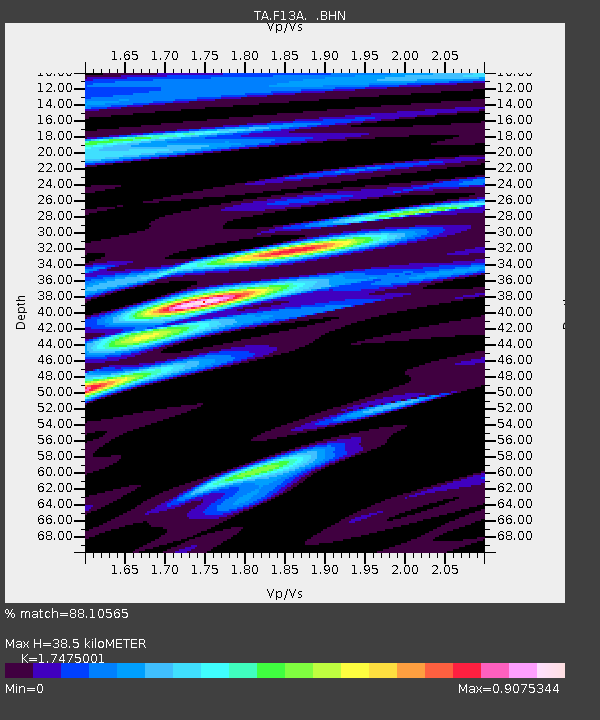
| Estimated Moho Depth: |
38.5 km |
| Estimated Crust Vp/Vs: |
1.75 |
| Assumed Crust Vp: |
6.577 km/s |
| Estimated Crust Vs: |
3.764 km/s |
| Estimated Crust Poisson's Ratio: |
0.26 |
|
| Radial Match: |
88.10565 % |
| Radial Bump: |
400 |
| Transverse Match: |
80.30624 % |
| Transverse Bump: |
400 |
| SOD ConfigId: |
2564 |
| Insert Time: |
2010-03-06 14:11:13.762 +0000 |
| GWidth: |
2.5 |
| Max Bumps: |
400 |
| Tol: |
0.001 |
|

Signal To Noise
| Channel | StoN | STA | LTA |
| TA:F13A: :BHN:20070930T02:20:54.899004Z | 1.3107126 | 9.199667E-8 | 7.0188285E-8 |
| TA:F13A: :BHE:20070930T02:20:54.899004Z | 1.9160616 | 1.5847348E-7 | 8.270792E-8 |
| TA:F13A: :BHZ:20070930T02:20:54.899004Z | 3.4090292 | 3.7546403E-7 | 1.1013811E-7 |
| Arrivals |
| Ps | 4.5 SECOND |
| PpPs | 16 SECOND |
| PsPs/PpSs | 20 SECOND |


