You are here: Home > Network List > N4 - Central and EAstern US Network Stations List
> Station L48A N Adams, MI, USA > Earthquake Result Viewer
L48A N Adams, MI, USA - Earthquake Result Viewer
| Earthquake location: |
Panama-Colombia Border Region |
| Earthquake latitude/longitude: |
8.8/-77.3 |
| Earthquake time(UTC): |
2018/08/18 (230) 19:39:07 GMT |
| Earthquake Depth: |
10 km |
| Earthquake Magnitude: |
5.6 Mww |
| Earthquake Catalog/Contributor: |
NEIC PDE/us |
|
| Network: |
N4 Central and EAstern US Network |
| Station: |
L48A N Adams, MI, USA |
| Lat/Lon: |
41.94 N/84.43 W |
| Elevation: |
369 m |
|
| Distance: |
33.6 deg |
| Az: |
350.349 deg |
| Baz: |
167.168 deg |
| Ray Param: |
0.078143716 |
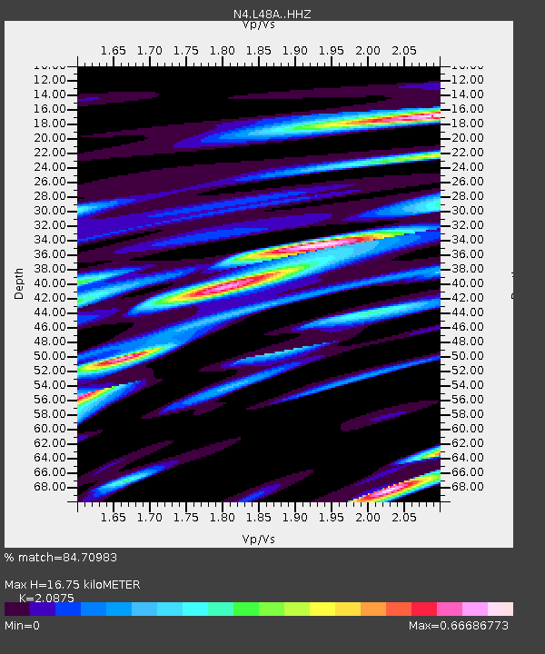
| Estimated Moho Depth: |
16.75 km |
| Estimated Crust Vp/Vs: |
2.09 |
| Assumed Crust Vp: |
6.498 km/s |
| Estimated Crust Vs: |
3.113 km/s |
| Estimated Crust Poisson's Ratio: |
0.35 |
|
| Radial Match: |
84.70983 % |
| Radial Bump: |
389 |
| Transverse Match: |
49.90377 % |
| Transverse Bump: |
400 |
| SOD ConfigId: |
13570011 |
| Insert Time: |
2019-04-30 20:47:02.618 +0000 |
| GWidth: |
2.5 |
| Max Bumps: |
400 |
| Tol: |
0.001 |
|

Signal To Noise
| Channel | StoN | STA | LTA |
| N4:L48A: :HHZ:20180818T19:45:16.860002Z | 3.6876347 | 3.871561E-7 | 1.0498765E-7 |
| N4:L48A: :HHN:20180818T19:45:16.860002Z | 2.5790818 | 2.6960637E-7 | 1.0453579E-7 |
| N4:L48A: :HHE:20180818T19:45:16.860002Z | 0.94060516 | 8.3952884E-8 | 8.9254115E-8 |
| Arrivals |
| Ps | 3.0 SECOND |
| PpPs | 7.4 SECOND |
| PsPs/PpSs | 10 SECOND |


