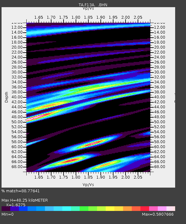
F13A Darby, MT, USA - Earthquake Result Viewer
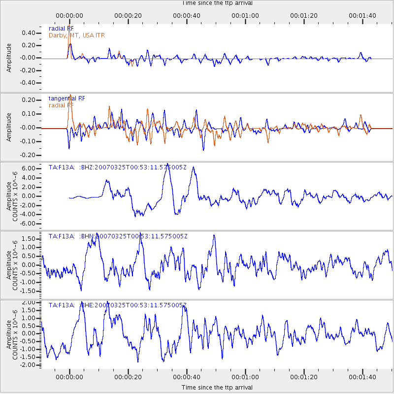
Earthquake location: Near West Coast Of Honshu, Japan
Earthquake latitude/longitude: 37.3/136.6
Earthquake time(UTC): 2007/03/25 (084) 00:41:57 GMT
Earthquake Depth: 8.0 km
Earthquake Magnitude: 6.1 MB, 6.8 MS, 6.7 MW, 6.6 MW
Earthquake Catalog/Contributor: WHDF/NEIC
Network: TA USArray Transportable Network (new EarthScope stations)
Station: F13A Darby, MT, USA
Lat/Lon: 45.79 N/114.33 W
Elevation: 1462 m
Distance: 75.6 deg
Az: 43.062 deg
Baz: 308.941 deg
Ray Param: 0.05158182
Estimated Moho Depth: 48.25 km
Estimated Crust Vp/Vs: 1.63
Assumed Crust Vp: 6.577 km/s
Estimated Crust Vs: 4.041 km/s
Estimated Crust Poisson's Ratio: 0.20
Radial Match: 88.77641 %
Radial Bump: 400
Transverse Match: 78.16503 %
Transverse Bump: 400
SOD ConfigId: 2564
Insert Time: 2010-03-06 14:12:03.729 +0000
GWidth: 2.5
Max Bumps: 400
Tol: 0.001

Signal To Noise

ChannelStoNSTALTA
TA:F13A: :BHN:20070325T00:53:11.575005Z2.65934326.308675E-72.3722681E-7
TA:F13A: :BHE:20070325T00:53:11.575005Z2.20507241.1516267E-65.222626E-7
TA:F13A: :BHZ:20070325T00:53:11.575005Z2.36605533.8844855E-61.6417561E-6
Arrivals
Ps4.8 SECOND
PpPs19 SECOND
PsPs/PpSs23 SECOND