You are here: Home > Network List > TA - USArray Transportable Network (new EarthScope stations) Stations List
> Station F13A Darby, MT, USA > Earthquake Result Viewer
F13A Darby, MT, USA - Earthquake Result Viewer

| Earthquake location: |
Kuril Islands |
| Earthquake latitude/longitude: |
46.0/151.4 |
| Earthquake time(UTC): |
2009/04/18 (108) 19:17:58 GMT |
| Earthquake Depth: |
35 km |
| Earthquake Magnitude: |
6.3 MB, 6.3 MS, 6.6 MW, 6.4 MW |
| Earthquake Catalog/Contributor: |
WHDF/NEIC |
|
| Network: |
TA USArray Transportable Network (new EarthScope stations) |
| Station: |
F13A Darby, MT, USA |
| Lat/Lon: |
45.79 N/114.33 W |
| Elevation: |
1462 m |
|
| Distance: |
61.6 deg |
| Az: |
52.523 deg |
| Baz: |
307.777 deg |
| Ray Param: |
0.060740594 |
| Estimated Moho Depth: |
19.0 km |
| Estimated Crust Vp/Vs: |
1.68 |
| Assumed Crust Vp: |
6.577 km/s |
| Estimated Crust Vs: |
3.927 km/s |
| Estimated Crust Poisson's Ratio: |
0.22 |
|
| Radial Match: |
93.46354 % |
| Radial Bump: |
400 |
| Transverse Match: |
77.636665 % |
| Transverse Bump: |
400 |
| SOD ConfigId: |
2760 |
| Insert Time: |
2010-03-06 14:12:22.772 +0000 |
| GWidth: |
2.5 |
| Max Bumps: |
400 |
| Tol: |
0.001 |
|
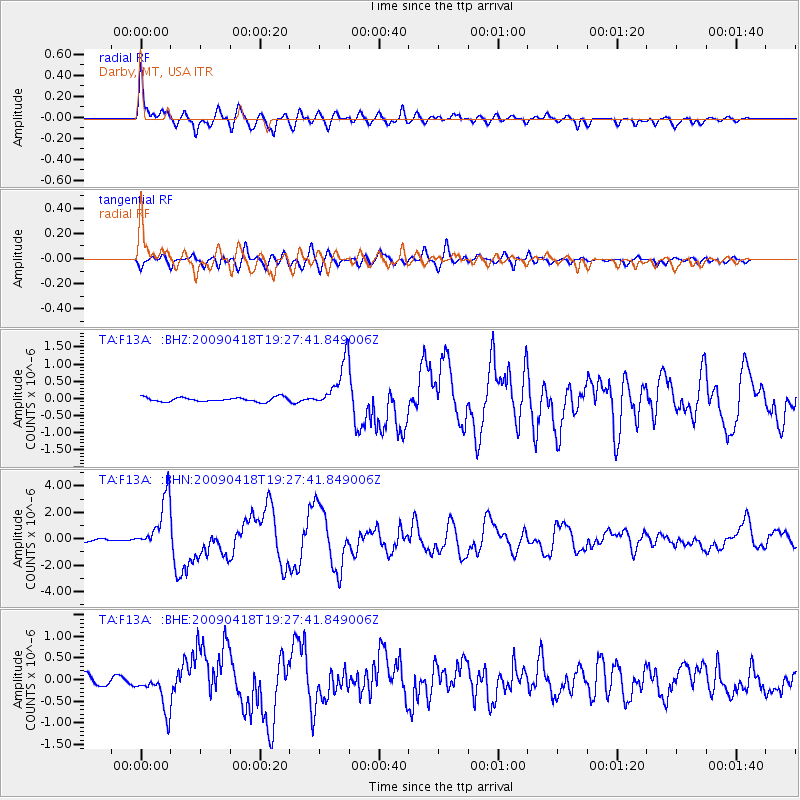
Signal To Noise
| Channel | StoN | STA | LTA |
| TA:F13A: :BHN:20090418T19:27:41.849006Z | 18.651333 | 1.9760016E-6 | 1.0594426E-7 |
| TA:F13A: :BHE:20090418T19:27:41.849006Z | 5.8015685 | 4.5126785E-7 | 7.778377E-8 |
| TA:F13A: :BHZ:20090418T19:27:41.849006Z | 11.135012 | 6.863611E-7 | 6.16399E-8 |
| Arrivals |
| Ps | 2.1 SECOND |
| PpPs | 7.3 SECOND |
| PsPs/PpSs | 9.4 SECOND |


