You are here: Home > Network List > TA - USArray Transportable Network (new EarthScope stations) Stations List
> Station M53A WI Miller and Sons, Farmdale, OH, USA > Earthquake Result Viewer
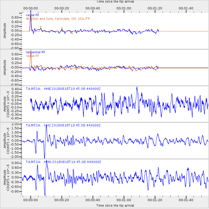
M53A WI Miller and Sons, Farmdale, OH, USA - Earthquake Result Viewer
*The percent match for this event was below the threshold and hence no stack was calculated.
| Earthquake location: |
Panama-Colombia Border Region |
| Earthquake latitude/longitude: |
8.8/-77.3 |
| Earthquake time(UTC): |
2018/08/18 (230) 19:39:07 GMT |
| Earthquake Depth: |
10 km |
| Earthquake Magnitude: |
5.6 Mww |
| Earthquake Catalog/Contributor: |
NEIC PDE/us |
|
| Network: |
TA USArray Transportable Network (new EarthScope stations) |
| Station: |
M53A WI Miller and Sons, Farmdale, OH, USA |
| Lat/Lon: |
41.44 N/80.68 W |
| Elevation: |
334 m |
|
| Distance: |
32.6 deg |
| Az: |
355.28 deg |
| Baz: |
173.791 deg |
| Ray Param: |
$rayparam |
*The percent match for this event was below the threshold and hence was not used in the summary stack. |
|
| Radial Match: |
77.6551 % |
| Radial Bump: |
361 |
| Transverse Match: |
56.866016 % |
| Transverse Bump: |
400 |
| SOD ConfigId: |
13570011 |
| Insert Time: |
2019-04-30 20:49:42.977 +0000 |
| GWidth: |
2.5 |
| Max Bumps: |
400 |
| Tol: |
0.001 |
|
Signal To Noise
| Channel | StoN | STA | LTA |
| TA:M53A: :HHZ:20180818T19:45:08.449999Z | 4.105115 | 5.355079E-7 | 1.3044894E-7 |
| TA:M53A: :HHN:20180818T19:45:08.449999Z | 3.4926329 | 3.2251214E-7 | 9.2340684E-8 |
| TA:M53A: :HHE:20180818T19:45:08.449999Z | 1.2969402 | 1.1756518E-7 | 9.0648115E-8 |
| Arrivals |
| Ps | |
| PpPs | |
| PsPs/PpSs | |


