You are here: Home > Network List > TA - USArray Transportable Network (new EarthScope stations) Stations List
> Station F13A Darby, MT, USA > Earthquake Result Viewer
F13A Darby, MT, USA - Earthquake Result Viewer
| Earthquake location: |
Off Coast Of Ecuador |
| Earthquake latitude/longitude: |
1.4/-85.2 |
| Earthquake time(UTC): |
2009/05/10 (130) 01:16:06 GMT |
| Earthquake Depth: |
6.0 km |
| Earthquake Magnitude: |
5.5 MB, 5.7 MS, 6.1 MW, 6.1 MW |
| Earthquake Catalog/Contributor: |
WHDF/NEIC |
|
| Network: |
TA USArray Transportable Network (new EarthScope stations) |
| Station: |
F13A Darby, MT, USA |
| Lat/Lon: |
45.79 N/114.33 W |
| Elevation: |
1462 m |
|
| Distance: |
51.1 deg |
| Az: |
334.013 deg |
| Baz: |
141.242 deg |
| Ray Param: |
0.0676404 |
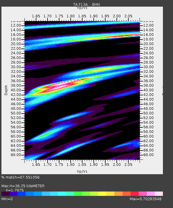
| Estimated Moho Depth: |
36.25 km |
| Estimated Crust Vp/Vs: |
1.79 |
| Assumed Crust Vp: |
6.577 km/s |
| Estimated Crust Vs: |
3.679 km/s |
| Estimated Crust Poisson's Ratio: |
0.27 |
|
| Radial Match: |
87.551056 % |
| Radial Bump: |
398 |
| Transverse Match: |
80.65214 % |
| Transverse Bump: |
400 |
| SOD ConfigId: |
2760 |
| Insert Time: |
2010-03-06 14:12:27.696 +0000 |
| GWidth: |
2.5 |
| Max Bumps: |
400 |
| Tol: |
0.001 |
|

Signal To Noise
| Channel | StoN | STA | LTA |
| TA:F13A: :BHN:20090510T01:24:39.199014Z | 6.946069 | 3.786374E-7 | 5.4511034E-8 |
| TA:F13A: :BHE:20090510T01:24:39.199014Z | 6.7856116 | 1.7208777E-7 | 2.5360686E-8 |
| TA:F13A: :BHZ:20090510T01:24:39.199014Z | 3.1095784 | 1.4209907E-7 | 4.5697213E-8 |
| Arrivals |
| Ps | 4.6 SECOND |
| PpPs | 14 SECOND |
| PsPs/PpSs | 19 SECOND |


