You are here: Home > Network List > TA - USArray Transportable Network (new EarthScope stations) Stations List
> Station P52A Corning, OH, USA > Earthquake Result Viewer
P52A Corning, OH, USA - Earthquake Result Viewer
| Earthquake location: |
Panama-Colombia Border Region |
| Earthquake latitude/longitude: |
8.8/-77.3 |
| Earthquake time(UTC): |
2018/08/18 (230) 19:39:07 GMT |
| Earthquake Depth: |
10 km |
| Earthquake Magnitude: |
5.6 Mww |
| Earthquake Catalog/Contributor: |
NEIC PDE/us |
|
| Network: |
TA USArray Transportable Network (new EarthScope stations) |
| Station: |
P52A Corning, OH, USA |
| Lat/Lon: |
39.63 N/82.13 W |
| Elevation: |
293 m |
|
| Distance: |
31.0 deg |
| Az: |
352.729 deg |
| Baz: |
170.678 deg |
| Ray Param: |
0.079190694 |
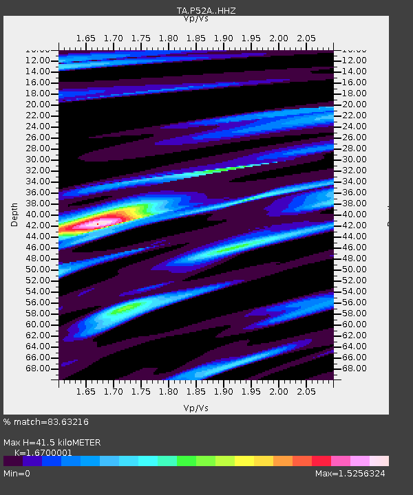
| Estimated Moho Depth: |
41.5 km |
| Estimated Crust Vp/Vs: |
1.67 |
| Assumed Crust Vp: |
6.232 km/s |
| Estimated Crust Vs: |
3.731 km/s |
| Estimated Crust Poisson's Ratio: |
0.22 |
|
| Radial Match: |
83.63216 % |
| Radial Bump: |
270 |
| Transverse Match: |
60.579426 % |
| Transverse Bump: |
354 |
| SOD ConfigId: |
13570011 |
| Insert Time: |
2019-04-30 20:49:54.996 +0000 |
| GWidth: |
2.5 |
| Max Bumps: |
400 |
| Tol: |
0.001 |
|

Signal To Noise
| Channel | StoN | STA | LTA |
| TA:P52A: :HHZ:20180818T19:44:54.120012Z | 5.254763 | 4.3061908E-7 | 8.194833E-8 |
| TA:P52A: :HHN:20180818T19:44:54.120012Z | 3.9695992 | 2.6231208E-7 | 6.608024E-8 |
| TA:P52A: :HHE:20180818T19:44:54.120012Z | 1.6073334 | 1.1890034E-7 | 7.3973666E-8 |
| Arrivals |
| Ps | 4.8 SECOND |
| PpPs | 16 SECOND |
| PsPs/PpSs | 21 SECOND |


