You are here: Home > Network List > TA - USArray Transportable Network (new EarthScope stations) Stations List
> Station T25A Trinidad, CO, USA > Earthquake Result Viewer
T25A Trinidad, CO, USA - Earthquake Result Viewer

| Earthquake location: |
Panama-Colombia Border Region |
| Earthquake latitude/longitude: |
8.8/-77.3 |
| Earthquake time(UTC): |
2018/08/18 (230) 19:39:07 GMT |
| Earthquake Depth: |
10 km |
| Earthquake Magnitude: |
5.6 Mww |
| Earthquake Catalog/Contributor: |
NEIC PDE/us |
|
| Network: |
TA USArray Transportable Network (new EarthScope stations) |
| Station: |
T25A Trinidad, CO, USA |
| Lat/Lon: |
37.14 N/104.41 W |
| Elevation: |
2017 m |
|
| Distance: |
37.4 deg |
| Az: |
323.13 deg |
| Baz: |
132.094 deg |
| Ray Param: |
0.07616846 |
| Estimated Moho Depth: |
41.25 km |
| Estimated Crust Vp/Vs: |
1.73 |
| Assumed Crust Vp: |
6.316 km/s |
| Estimated Crust Vs: |
3.645 km/s |
| Estimated Crust Poisson's Ratio: |
0.25 |
|
| Radial Match: |
88.76978 % |
| Radial Bump: |
303 |
| Transverse Match: |
74.095535 % |
| Transverse Bump: |
400 |
| SOD ConfigId: |
13570011 |
| Insert Time: |
2019-04-30 20:50:00.649 +0000 |
| GWidth: |
2.5 |
| Max Bumps: |
400 |
| Tol: |
0.001 |
|
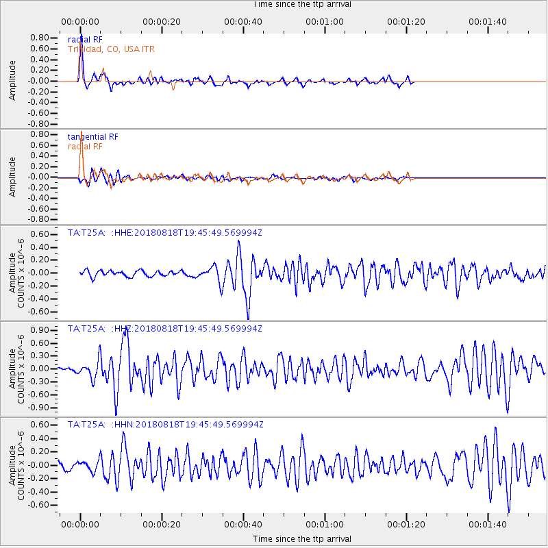
Signal To Noise
| Channel | StoN | STA | LTA |
| TA:T25A: :HHZ:20180818T19:45:49.569994Z | 3.352364 | 1.9899993E-7 | 5.936107E-8 |
| TA:T25A: :HHN:20180818T19:45:49.569994Z | 1.2059942 | 7.7213315E-8 | 6.402461E-8 |
| TA:T25A: :HHE:20180818T19:45:49.569994Z | 2.5090556 | 1.0929847E-7 | 4.3561595E-8 |
| Arrivals |
| Ps | 5.1 SECOND |
| PpPs | 17 SECOND |
| PsPs/PpSs | 22 SECOND |


