F13A Darby, MT, USA - Earthquake Result Viewer
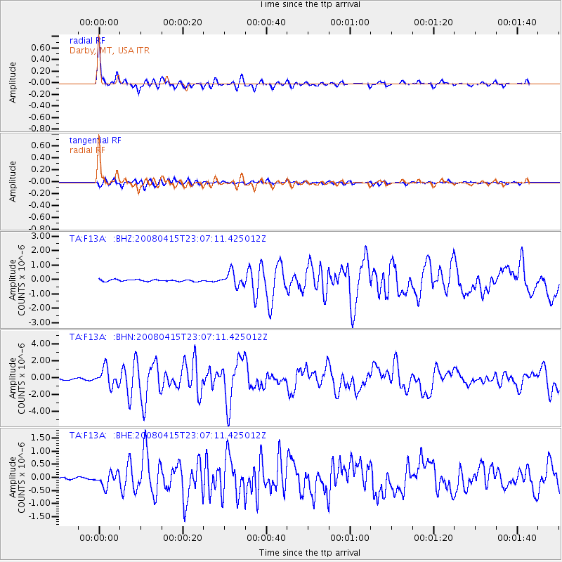
Earthquake location: Andreanof Islands, Aleutian Is.
Earthquake latitude/longitude: 51.9/-179.4
Earthquake time(UTC): 2008/04/15 (106) 22:59:51 GMT
Earthquake Depth: 10 km
Earthquake Magnitude: 6.1 MB, 6.4 MS, 6.4 MW, 6.4 MW
Earthquake Catalog/Contributor: WHDF/NEIC
Network: TA USArray Transportable Network (new EarthScope stations)
Station: F13A Darby, MT, USA
Lat/Lon: 45.79 N/114.33 W
Elevation: 1462 m
Distance: 42.0 deg
Az: 71.568 deg
Baz: 302.759 deg
Ray Param: 0.07346168
Estimated Moho Depth: 45.0 km
Estimated Crust Vp/Vs: 1.60
Assumed Crust Vp: 6.577 km/s
Estimated Crust Vs: 4.111 km/s
Estimated Crust Poisson's Ratio: 0.18
Radial Match: 93.0755 %
Radial Bump: 388
Transverse Match: 81.053986 %
Transverse Bump: 400
SOD ConfigId: 2504
Insert Time: 2010-03-06 14:12:38.141 +0000
GWidth: 2.5
Max Bumps: 400
Tol: 0.001

Signal To Noise

ChannelStoNSTALTA
TA:F13A: :BHN:20080415T23:07:11.425012Z10.0189241.0878758E-61.08582114E-7
TA:F13A: :BHE:20080415T23:07:11.425012Z5.18832832.6538663E-75.1150703E-8
TA:F13A: :BHZ:20080415T23:07:11.425012Z8.5135634.9045354E-75.7608492E-8
Arrivals
Ps4.4 SECOND
PpPs16 SECOND
PsPs/PpSs21 SECOND