You are here: Home > Network List > AK - Alaska Regional Network Stations List
> Station ANM Anvil Mountian > Earthquake Result Viewer
ANM Anvil Mountian - Earthquake Result Viewer
| Earthquake location: |
Fiji Islands Region |
| Earthquake latitude/longitude: |
-18.2/-178.1 |
| Earthquake time(UTC): |
2018/08/19 (231) 00:19:37 GMT |
| Earthquake Depth: |
563 km |
| Earthquake Magnitude: |
8.2 mww |
| Earthquake Catalog/Contributor: |
NEIC PDE/us |
|
| Network: |
AK Alaska Regional Network |
| Station: |
ANM Anvil Mountian |
| Lat/Lon: |
64.56 N/165.37 W |
| Elevation: |
330 m |
|
| Distance: |
83.1 deg |
| Az: |
5.507 deg |
| Baz: |
192.194 deg |
| Ray Param: |
0.044792544 |
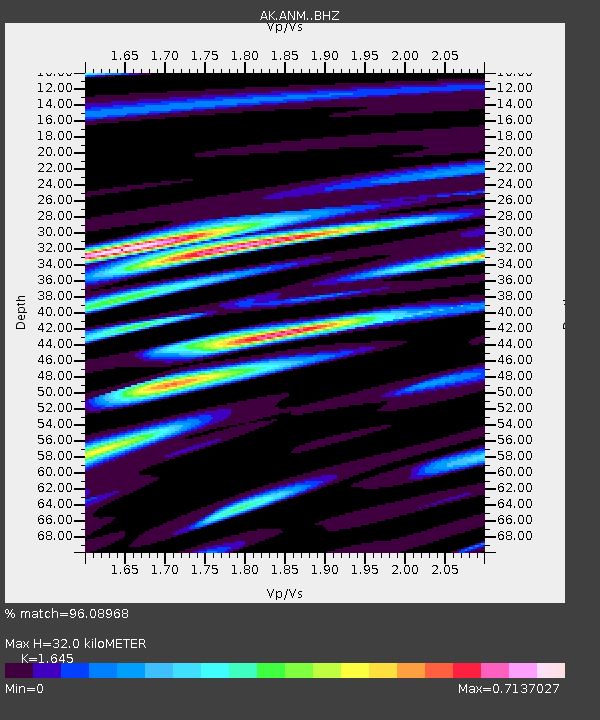
| Estimated Moho Depth: |
32.0 km |
| Estimated Crust Vp/Vs: |
1.64 |
| Assumed Crust Vp: |
6.276 km/s |
| Estimated Crust Vs: |
3.815 km/s |
| Estimated Crust Poisson's Ratio: |
0.21 |
|
| Radial Match: |
96.08968 % |
| Radial Bump: |
400 |
| Transverse Match: |
89.12532 % |
| Transverse Bump: |
400 |
| SOD ConfigId: |
13570011 |
| Insert Time: |
2019-04-30 20:52:31.791 +0000 |
| GWidth: |
2.5 |
| Max Bumps: |
400 |
| Tol: |
0.001 |
|

Signal To Noise
| Channel | StoN | STA | LTA |
| AK:ANM: :BHZ:20180819T00:30:32.847991Z | 3.8329747 | 6.268798E-6 | 1.6354917E-6 |
| AK:ANM: :BHN:20180819T00:30:32.847991Z | 4.0179887 | 2.7428327E-6 | 6.826383E-7 |
| AK:ANM: :BHE:20180819T00:30:32.847991Z | 1.4995264 | 4.2356578E-7 | 2.8246637E-7 |
| Arrivals |
| Ps | 3.4 SECOND |
| PpPs | 13 SECOND |
| PsPs/PpSs | 17 SECOND |


