You are here: Home > Network List > AK - Alaska Regional Network Stations List
> Station BARK Barkley Ridge, AK, USA > Earthquake Result Viewer
BARK Barkley Ridge, AK, USA - Earthquake Result Viewer
| Earthquake location: |
Fiji Islands Region |
| Earthquake latitude/longitude: |
-18.2/-178.1 |
| Earthquake time(UTC): |
2018/08/19 (231) 00:19:37 GMT |
| Earthquake Depth: |
563 km |
| Earthquake Magnitude: |
8.2 mww |
| Earthquake Catalog/Contributor: |
NEIC PDE/us |
|
| Network: |
AK Alaska Regional Network |
| Station: |
BARK Barkley Ridge, AK, USA |
| Lat/Lon: |
60.40 N/142.49 W |
| Elevation: |
1390 m |
|
| Distance: |
83.4 deg |
| Az: |
16.918 deg |
| Baz: |
213.872 deg |
| Ray Param: |
0.04453982 |
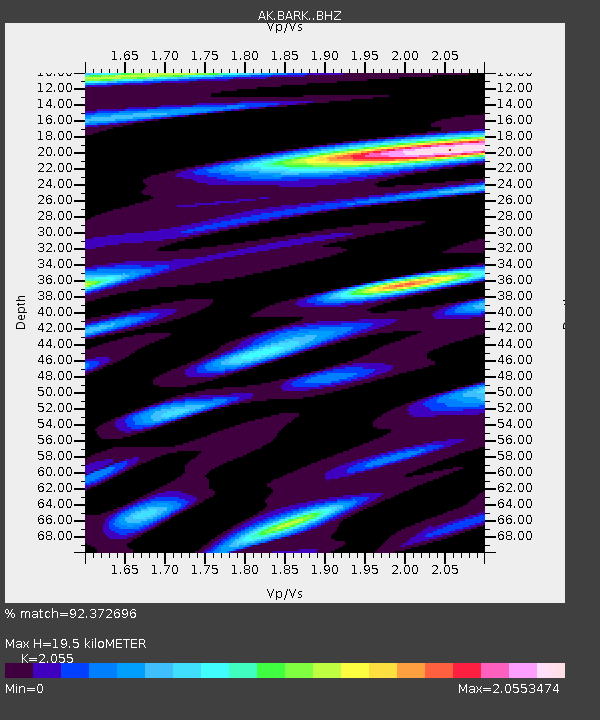
| Estimated Moho Depth: |
19.5 km |
| Estimated Crust Vp/Vs: |
2.06 |
| Assumed Crust Vp: |
6.566 km/s |
| Estimated Crust Vs: |
3.195 km/s |
| Estimated Crust Poisson's Ratio: |
0.34 |
|
| Radial Match: |
92.372696 % |
| Radial Bump: |
400 |
| Transverse Match: |
85.78759 % |
| Transverse Bump: |
400 |
| SOD ConfigId: |
13570011 |
| Insert Time: |
2019-04-30 20:52:33.044 +0000 |
| GWidth: |
2.5 |
| Max Bumps: |
400 |
| Tol: |
0.001 |
|

Signal To Noise
| Channel | StoN | STA | LTA |
| AK:BARK: :BHZ:20180819T00:30:34.707976Z | 7.9571357 | 9.993315E-6 | 1.2558935E-6 |
| AK:BARK: :BHN:20180819T00:30:34.707976Z | 3.5825045 | 4.6959412E-6 | 1.3107984E-6 |
| AK:BARK: :BHE:20180819T00:30:34.707976Z | 6.749101 | 6.0436873E-6 | 8.9548035E-7 |
| Arrivals |
| Ps | 3.2 SECOND |
| PpPs | 8.9 SECOND |
| PsPs/PpSs | 12 SECOND |


