You are here: Home > Network List > AK - Alaska Regional Network Stations List
> Station BESE Bessie Mountain > Earthquake Result Viewer
BESE Bessie Mountain - Earthquake Result Viewer
| Earthquake location: |
Fiji Islands Region |
| Earthquake latitude/longitude: |
-18.2/-178.1 |
| Earthquake time(UTC): |
2018/08/19 (231) 00:19:37 GMT |
| Earthquake Depth: |
563 km |
| Earthquake Magnitude: |
8.2 mww |
| Earthquake Catalog/Contributor: |
NEIC PDE/us |
|
| Network: |
AK Alaska Regional Network |
| Station: |
BESE Bessie Mountain |
| Lat/Lon: |
58.58 N/134.85 W |
| Elevation: |
870 m |
|
| Distance: |
84.3 deg |
| Az: |
21.146 deg |
| Baz: |
220.895 deg |
| Ray Param: |
0.043914903 |
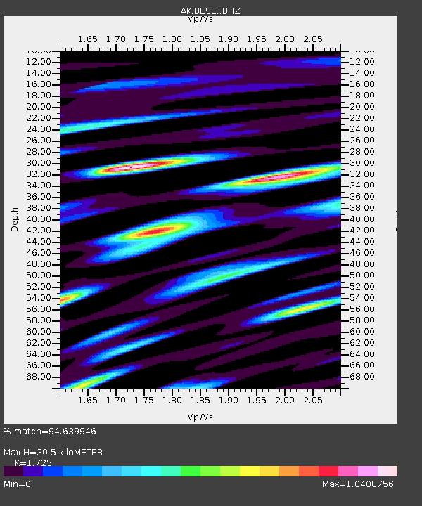
| Estimated Moho Depth: |
30.5 km |
| Estimated Crust Vp/Vs: |
1.73 |
| Assumed Crust Vp: |
6.566 km/s |
| Estimated Crust Vs: |
3.806 km/s |
| Estimated Crust Poisson's Ratio: |
0.25 |
|
| Radial Match: |
94.639946 % |
| Radial Bump: |
400 |
| Transverse Match: |
84.58016 % |
| Transverse Bump: |
400 |
| SOD ConfigId: |
13570011 |
| Insert Time: |
2019-04-30 20:52:33.982 +0000 |
| GWidth: |
2.5 |
| Max Bumps: |
400 |
| Tol: |
0.001 |
|

Signal To Noise
| Channel | StoN | STA | LTA |
| AK:BESE: :BHZ:20180819T00:30:39.207976Z | 4.814472 | 4.925263E-6 | 1.0230121E-6 |
| AK:BESE: :BHN:20180819T00:30:39.207976Z | 1.6914282 | 1.3283468E-6 | 7.853404E-7 |
| AK:BESE: :BHE:20180819T00:30:39.207976Z | 1.7437377 | 8.658816E-7 | 4.9656643E-7 |
| Arrivals |
| Ps | 3.5 SECOND |
| PpPs | 12 SECOND |
| PsPs/PpSs | 16 SECOND |


