You are here: Home > Network List > AK - Alaska Regional Network Stations List
> Station FALS False Pass > Earthquake Result Viewer
FALS False Pass - Earthquake Result Viewer
| Earthquake location: |
Fiji Islands Region |
| Earthquake latitude/longitude: |
-18.2/-178.1 |
| Earthquake time(UTC): |
2018/08/19 (231) 00:19:37 GMT |
| Earthquake Depth: |
563 km |
| Earthquake Magnitude: |
8.2 mww |
| Earthquake Catalog/Contributor: |
NEIC PDE/us |
|
| Network: |
AK Alaska Regional Network |
| Station: |
FALS False Pass |
| Lat/Lon: |
54.86 N/163.42 W |
| Elevation: |
46 m |
|
| Distance: |
73.8 deg |
| Az: |
8.785 deg |
| Baz: |
194.544 deg |
| Ray Param: |
0.05091055 |
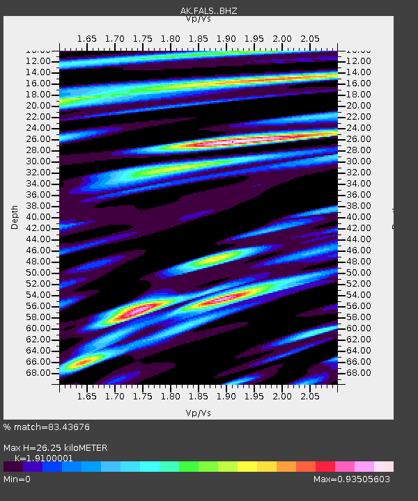
| Estimated Moho Depth: |
26.25 km |
| Estimated Crust Vp/Vs: |
1.91 |
| Assumed Crust Vp: |
5.989 km/s |
| Estimated Crust Vs: |
3.136 km/s |
| Estimated Crust Poisson's Ratio: |
0.31 |
|
| Radial Match: |
83.43676 % |
| Radial Bump: |
400 |
| Transverse Match: |
71.70557 % |
| Transverse Bump: |
400 |
| SOD ConfigId: |
13570011 |
| Insert Time: |
2019-04-30 20:52:51.181 +0000 |
| GWidth: |
2.5 |
| Max Bumps: |
400 |
| Tol: |
0.001 |
|

Signal To Noise
| Channel | StoN | STA | LTA |
| AK:FALS: :BHZ:20180819T00:29:43.86801Z | 15.266533 | 2.6077792E-5 | 1.7081674E-6 |
| AK:FALS: :BHN:20180819T00:29:43.86801Z | 12.651663 | 2.337119E-5 | 1.8472821E-6 |
| AK:FALS: :BHE:20180819T00:29:43.86801Z | 4.284419 | 6.954095E-6 | 1.6231128E-6 |
| Arrivals |
| Ps | 4.1 SECOND |
| PpPs | 12 SECOND |
| PsPs/PpSs | 17 SECOND |


