You are here: Home > Network List > AK - Alaska Regional Network Stations List
> Station KAI Kayak Island, AK, USA > Earthquake Result Viewer
KAI Kayak Island, AK, USA - Earthquake Result Viewer
| Earthquake location: |
Fiji Islands Region |
| Earthquake latitude/longitude: |
-18.2/-178.1 |
| Earthquake time(UTC): |
2018/08/19 (231) 00:19:37 GMT |
| Earthquake Depth: |
563 km |
| Earthquake Magnitude: |
8.2 mww |
| Earthquake Catalog/Contributor: |
NEIC PDE/us |
|
| Network: |
AK Alaska Regional Network |
| Station: |
KAI Kayak Island, AK, USA |
| Lat/Lon: |
59.93 N/144.42 W |
| Elevation: |
316 m |
|
| Distance: |
82.5 deg |
| Az: |
16.368 deg |
| Baz: |
212.138 deg |
| Ray Param: |
0.04517458 |
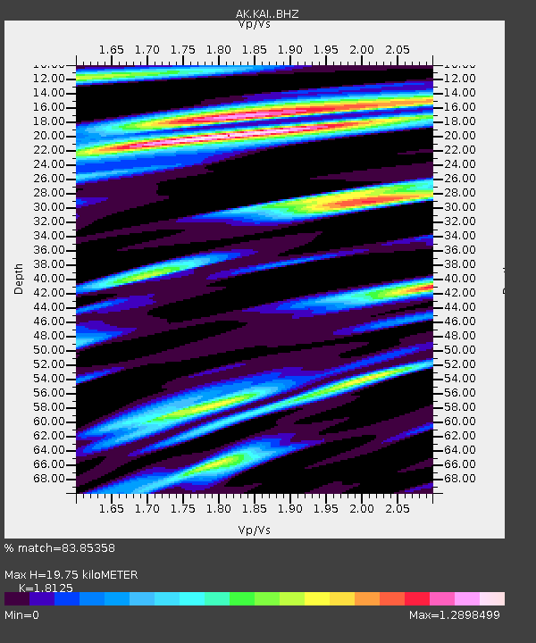
| Estimated Moho Depth: |
19.75 km |
| Estimated Crust Vp/Vs: |
1.81 |
| Assumed Crust Vp: |
5.88 km/s |
| Estimated Crust Vs: |
3.244 km/s |
| Estimated Crust Poisson's Ratio: |
0.28 |
|
| Radial Match: |
83.85358 % |
| Radial Bump: |
400 |
| Transverse Match: |
74.74819 % |
| Transverse Bump: |
400 |
| SOD ConfigId: |
13570011 |
| Insert Time: |
2019-04-30 20:53:06.434 +0000 |
| GWidth: |
2.5 |
| Max Bumps: |
400 |
| Tol: |
0.001 |
|

Signal To Noise
| Channel | StoN | STA | LTA |
| AK:KAI: :BHZ:20180819T00:30:30.108Z | 6.693767 | 6.9361727E-6 | 1.0362137E-6 |
| AK:KAI: :BHN:20180819T00:30:30.108Z | 5.035055 | 3.5885735E-6 | 7.127178E-7 |
| AK:KAI: :BHE:20180819T00:30:30.108Z | 6.0674553 | 3.4689394E-6 | 5.717289E-7 |
| Arrivals |
| Ps | 2.8 SECOND |
| PpPs | 9.3 SECOND |
| PsPs/PpSs | 12 SECOND |


