You are here: Home > Network List > AU - Australian Seismological Centre Stations List
> Station BLDU Ballidu, Western Australia > Earthquake Result Viewer
BLDU Ballidu, Western Australia - Earthquake Result Viewer
| Earthquake location: |
Fiji Islands Region |
| Earthquake latitude/longitude: |
-18.2/-178.1 |
| Earthquake time(UTC): |
2018/08/19 (231) 00:19:37 GMT |
| Earthquake Depth: |
563 km |
| Earthquake Magnitude: |
8.2 mww |
| Earthquake Catalog/Contributor: |
NEIC PDE/us |
|
| Network: |
AU Australian Seismological Centre |
| Station: |
BLDU Ballidu, Western Australia |
| Lat/Lon: |
30.61 S/116.71 E |
| Elevation: |
280 m |
|
| Distance: |
59.9 deg |
| Az: |
244.72 deg |
| Baz: |
94.314 deg |
| Ray Param: |
0.059643768 |
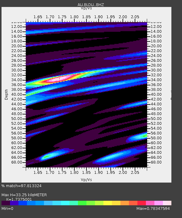
| Estimated Moho Depth: |
33.25 km |
| Estimated Crust Vp/Vs: |
1.74 |
| Assumed Crust Vp: |
6.419 km/s |
| Estimated Crust Vs: |
3.695 km/s |
| Estimated Crust Poisson's Ratio: |
0.25 |
|
| Radial Match: |
97.813324 % |
| Radial Bump: |
238 |
| Transverse Match: |
93.29979 % |
| Transverse Bump: |
400 |
| SOD ConfigId: |
13570011 |
| Insert Time: |
2019-04-30 20:53:54.778 +0000 |
| GWidth: |
2.5 |
| Max Bumps: |
400 |
| Tol: |
0.001 |
|

Signal To Noise
| Channel | StoN | STA | LTA |
| AU:BLDU: :BHZ:20180819T00:28:19.243987Z | 3.3093042 | 5.7928605E-6 | 1.7504769E-6 |
| AU:BLDU: :BHN:20180819T00:28:19.243987Z | 2.5442634 | 7.210247E-7 | 2.833923E-7 |
| AU:BLDU: :BHE:20180819T00:28:19.243987Z | 3.2335114 | 3.6364668E-6 | 1.1246185E-6 |
| Arrivals |
| Ps | 4.0 SECOND |
| PpPs | 14 SECOND |
| PsPs/PpSs | 18 SECOND |


