You are here: Home > Network List > AU - Australian Seismological Centre Stations List
> Station CMSA Cobar, New South Wales > Earthquake Result Viewer
CMSA Cobar, New South Wales - Earthquake Result Viewer
| Earthquake location: |
Fiji Islands Region |
| Earthquake latitude/longitude: |
-18.2/-178.1 |
| Earthquake time(UTC): |
2018/08/19 (231) 00:19:37 GMT |
| Earthquake Depth: |
563 km |
| Earthquake Magnitude: |
8.2 mww |
| Earthquake Catalog/Contributor: |
NEIC PDE/us |
|
| Network: |
AU Australian Seismological Centre |
| Station: |
CMSA Cobar, New South Wales |
| Lat/Lon: |
31.54 S/145.69 E |
| Elevation: |
220 m |
|
| Distance: |
35.3 deg |
| Az: |
240.855 deg |
| Baz: |
76.521 deg |
| Ray Param: |
0.07450905 |
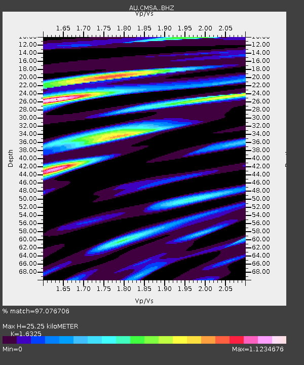
| Estimated Moho Depth: |
25.25 km |
| Estimated Crust Vp/Vs: |
1.63 |
| Assumed Crust Vp: |
6.522 km/s |
| Estimated Crust Vs: |
3.995 km/s |
| Estimated Crust Poisson's Ratio: |
0.20 |
|
| Radial Match: |
97.076706 % |
| Radial Bump: |
382 |
| Transverse Match: |
92.55888 % |
| Transverse Bump: |
400 |
| SOD ConfigId: |
13570011 |
| Insert Time: |
2019-04-30 20:53:56.498 +0000 |
| GWidth: |
2.5 |
| Max Bumps: |
400 |
| Tol: |
0.001 |
|

Signal To Noise
| Channel | StoN | STA | LTA |
| AU:CMSA: :BHZ:20180819T00:25:16.169005Z | 5.536543 | 8.139545E-6 | 1.4701492E-6 |
| AU:CMSA: :BHN:20180819T00:25:16.169005Z | 3.8237462 | 2.0195148E-6 | 5.281508E-7 |
| AU:CMSA: :BHE:20180819T00:25:16.169005Z | 5.2868977 | 5.573851E-6 | 1.0542764E-6 |
| Arrivals |
| Ps | 2.7 SECOND |
| PpPs | 9.4 SECOND |
| PsPs/PpSs | 12 SECOND |


