You are here: Home > Network List > AU - Australian Seismological Centre Stations List
> Station MEEK Meekatharra, Western Australia > Earthquake Result Viewer
MEEK Meekatharra, Western Australia - Earthquake Result Viewer
| Earthquake location: |
Fiji Islands Region |
| Earthquake latitude/longitude: |
-18.2/-178.1 |
| Earthquake time(UTC): |
2018/08/19 (231) 00:19:37 GMT |
| Earthquake Depth: |
563 km |
| Earthquake Magnitude: |
8.2 mww |
| Earthquake Catalog/Contributor: |
NEIC PDE/us |
|
| Network: |
AU Australian Seismological Centre |
| Station: |
MEEK Meekatharra, Western Australia |
| Lat/Lon: |
26.64 S/118.61 E |
| Elevation: |
530 m |
|
| Distance: |
58.6 deg |
| Az: |
249.484 deg |
| Baz: |
95.841 deg |
| Ray Param: |
0.06046042 |
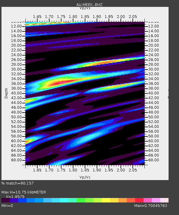
| Estimated Moho Depth: |
10.75 km |
| Estimated Crust Vp/Vs: |
1.66 |
| Assumed Crust Vp: |
6.459 km/s |
| Estimated Crust Vs: |
3.897 km/s |
| Estimated Crust Poisson's Ratio: |
0.21 |
|
| Radial Match: |
98.157 % |
| Radial Bump: |
259 |
| Transverse Match: |
89.54703 % |
| Transverse Bump: |
400 |
| SOD ConfigId: |
13570011 |
| Insert Time: |
2019-04-30 20:54:01.116 +0000 |
| GWidth: |
2.5 |
| Max Bumps: |
400 |
| Tol: |
0.001 |
|

Signal To Noise
| Channel | StoN | STA | LTA |
| AU:MEEK: :BHZ:20180819T00:28:10.469023Z | 3.116844 | 6.918763E-6 | 2.2197978E-6 |
| AU:MEEK: :BHN:20180819T00:28:10.469023Z | 1.5058186 | 3.5739333E-7 | 2.3734157E-7 |
| AU:MEEK: :BHE:20180819T00:28:10.469023Z | 3.2334626 | 4.7182148E-6 | 1.4591834E-6 |
| Arrivals |
| Ps | 1.1 SECOND |
| PpPs | 4.2 SECOND |
| PsPs/PpSs | 5.4 SECOND |


