You are here: Home > Network List > TA - USArray Transportable Network (new EarthScope stations) Stations List
> Station F13A Darby, MT, USA > Earthquake Result Viewer
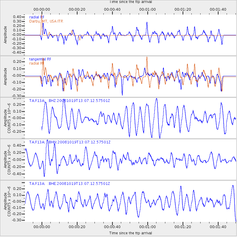
F13A Darby, MT, USA - Earthquake Result Viewer
*The percent match for this event was below the threshold and hence no stack was calculated.
| Earthquake location: |
Tonga Islands |
| Earthquake latitude/longitude: |
-22.0/-173.7 |
| Earthquake time(UTC): |
2008/10/19 (293) 12:55:05 GMT |
| Earthquake Depth: |
35 km |
| Earthquake Magnitude: |
5.7 MB, 5.3 MS, 5.6 MW, 5.5 MW |
| Earthquake Catalog/Contributor: |
WHDF/NEIC |
|
| Network: |
TA USArray Transportable Network (new EarthScope stations) |
| Station: |
F13A Darby, MT, USA |
| Lat/Lon: |
45.79 N/114.33 W |
| Elevation: |
1462 m |
|
| Distance: |
86.3 deg |
| Az: |
37.11 deg |
| Baz: |
233.169 deg |
| Ray Param: |
$rayparam |
*The percent match for this event was below the threshold and hence was not used in the summary stack. |
|
| Radial Match: |
68.93103 % |
| Radial Bump: |
332 |
| Transverse Match: |
69.43343 % |
| Transverse Bump: |
393 |
| SOD ConfigId: |
2556 |
| Insert Time: |
2010-03-06 14:13:45.587 +0000 |
| GWidth: |
2.5 |
| Max Bumps: |
400 |
| Tol: |
0.001 |
|
Signal To Noise
| Channel | StoN | STA | LTA |
| TA:F13A: :BHN:20081019T13:07:12.57501Z | 1.5461389 | 3.080507E-7 | 1.9923868E-7 |
| TA:F13A: :BHE:20081019T13:07:12.57501Z | 1.0602174 | 9.392008E-8 | 8.858568E-8 |
| TA:F13A: :BHZ:20081019T13:07:12.57501Z | 0.5042319 | 6.295064E-8 | 1.248446E-7 |
| Arrivals |
| Ps | |
| PpPs | |
| PsPs/PpSs | |


