You are here: Home > Network List > AV - Alaska Volcano Observatory Stations List
> Station MAPS Pakushin Southeast, Makushin Volcano, Alaska > Earthquake Result Viewer
MAPS Pakushin Southeast, Makushin Volcano, Alaska - Earthquake Result Viewer
| Earthquake location: |
Fiji Islands Region |
| Earthquake latitude/longitude: |
-18.2/-178.1 |
| Earthquake time(UTC): |
2018/08/19 (231) 00:19:37 GMT |
| Earthquake Depth: |
563 km |
| Earthquake Magnitude: |
8.2 mww |
| Earthquake Catalog/Contributor: |
NEIC PDE/us |
|
| Network: |
AV Alaska Volcano Observatory |
| Station: |
MAPS Pakushin Southeast, Makushin Volcano, Alaska |
| Lat/Lon: |
53.81 N/166.94 W |
| Elevation: |
333 m |
|
| Distance: |
72.3 deg |
| Az: |
6.926 deg |
| Baz: |
191.145 deg |
| Ray Param: |
0.051862534 |
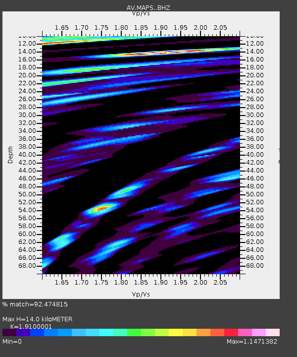
| Estimated Moho Depth: |
14.0 km |
| Estimated Crust Vp/Vs: |
1.91 |
| Assumed Crust Vp: |
3.943 km/s |
| Estimated Crust Vs: |
2.065 km/s |
| Estimated Crust Poisson's Ratio: |
0.31 |
|
| Radial Match: |
92.474815 % |
| Radial Bump: |
400 |
| Transverse Match: |
84.272064 % |
| Transverse Bump: |
400 |
| SOD ConfigId: |
13570011 |
| Insert Time: |
2019-04-30 20:54:26.024 +0000 |
| GWidth: |
2.5 |
| Max Bumps: |
400 |
| Tol: |
0.001 |
|
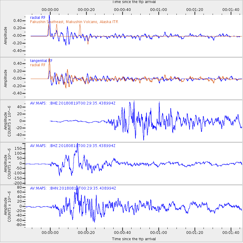
Signal To Noise
| Channel | StoN | STA | LTA |
| AV:MAPS: :BHZ:20180819T00:29:35.438994Z | 21.059895 | 1.947268E-5 | 9.2463324E-7 |
| AV:MAPS: :BHN:20180819T00:29:35.438994Z | 3.9384665 | 5.1401275E-6 | 1.3051088E-6 |
| AV:MAPS: :BHE:20180819T00:29:35.438994Z | 2.2634368 | 4.0295863E-6 | 1.7802955E-6 |
| Arrivals |
| Ps | 3.3 SECOND |
| PpPs | 10 SECOND |
| PsPs/PpSs | 13 SECOND |


