You are here: Home > Network List > AV - Alaska Volcano Observatory Stations List
> Station MTBL Table Top, Makushin Volcano, Alaska > Earthquake Result Viewer
MTBL Table Top, Makushin Volcano, Alaska - Earthquake Result Viewer
| Earthquake location: |
Fiji Islands Region |
| Earthquake latitude/longitude: |
-18.2/-178.1 |
| Earthquake time(UTC): |
2018/08/19 (231) 00:19:37 GMT |
| Earthquake Depth: |
563 km |
| Earthquake Magnitude: |
8.2 mww |
| Earthquake Catalog/Contributor: |
NEIC PDE/us |
|
| Network: |
AV Alaska Volcano Observatory |
| Station: |
MTBL Table Top, Makushin Volcano, Alaska |
| Lat/Lon: |
53.97 N/166.68 W |
| Elevation: |
810 m |
|
| Distance: |
72.5 deg |
| Az: |
7.051 deg |
| Baz: |
191.392 deg |
| Ray Param: |
0.051745724 |
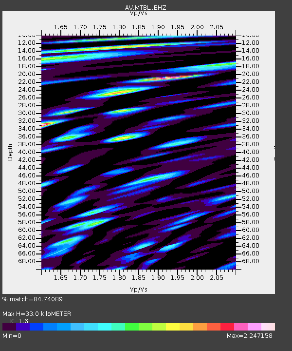
| Estimated Moho Depth: |
33.0 km |
| Estimated Crust Vp/Vs: |
1.60 |
| Assumed Crust Vp: |
3.943 km/s |
| Estimated Crust Vs: |
2.465 km/s |
| Estimated Crust Poisson's Ratio: |
0.18 |
|
| Radial Match: |
84.74089 % |
| Radial Bump: |
400 |
| Transverse Match: |
86.48729 % |
| Transverse Bump: |
400 |
| SOD ConfigId: |
13570011 |
| Insert Time: |
2019-04-30 20:54:30.361 +0000 |
| GWidth: |
2.5 |
| Max Bumps: |
400 |
| Tol: |
0.001 |
|

Signal To Noise
| Channel | StoN | STA | LTA |
| AV:MTBL: :BHZ:20180819T00:29:36.500029Z | 16.88105 | 3.0354382E-5 | 1.7981336E-6 |
| AV:MTBL: :BHN:20180819T00:29:36.500029Z | 6.0034 | 2.3235725E-5 | 3.870428E-6 |
| AV:MTBL: :BHE:20180819T00:29:36.500029Z | 5.876113 | 2.6371254E-5 | 4.487874E-6 |
| Arrivals |
| Ps | 5.1 SECOND |
| PpPs | 21 SECOND |
| PsPs/PpSs | 27 SECOND |


