You are here: Home > Network List > AV - Alaska Volcano Observatory Stations List
> Station PLK2 Mt. Peulik Volcano 2, Alaska > Earthquake Result Viewer
PLK2 Mt. Peulik Volcano 2, Alaska - Earthquake Result Viewer
| Earthquake location: |
Fiji Islands Region |
| Earthquake latitude/longitude: |
-18.2/-178.1 |
| Earthquake time(UTC): |
2018/08/19 (231) 00:19:37 GMT |
| Earthquake Depth: |
563 km |
| Earthquake Magnitude: |
8.2 mww |
| Earthquake Catalog/Contributor: |
NEIC PDE/us |
|
| Network: |
AV Alaska Volcano Observatory |
| Station: |
PLK2 Mt. Peulik Volcano 2, Alaska |
| Lat/Lon: |
57.76 N/156.33 W |
| Elevation: |
401 m |
|
| Distance: |
77.8 deg |
| Az: |
11.742 deg |
| Baz: |
201.161 deg |
| Ray Param: |
0.0483256 |
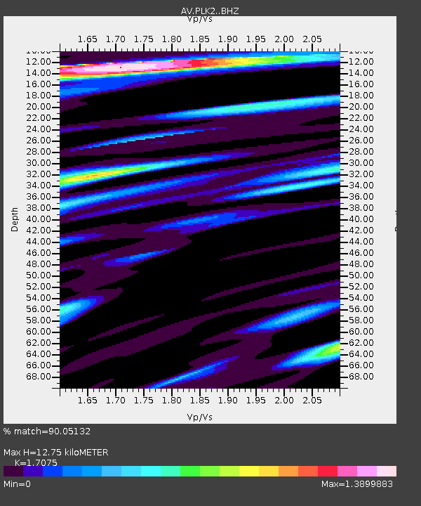
| Estimated Moho Depth: |
12.75 km |
| Estimated Crust Vp/Vs: |
1.71 |
| Assumed Crust Vp: |
6.1 km/s |
| Estimated Crust Vs: |
3.572 km/s |
| Estimated Crust Poisson's Ratio: |
0.24 |
|
| Radial Match: |
90.05132 % |
| Radial Bump: |
400 |
| Transverse Match: |
86.070816 % |
| Transverse Bump: |
400 |
| SOD ConfigId: |
13570011 |
| Insert Time: |
2019-04-30 20:54:34.789 +0000 |
| GWidth: |
2.5 |
| Max Bumps: |
400 |
| Tol: |
0.001 |
|
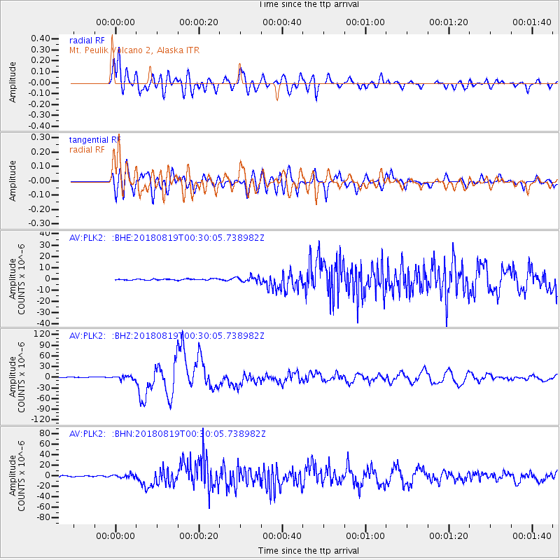
Signal To Noise
| Channel | StoN | STA | LTA |
| AV:PLK2: :BHZ:20180819T00:30:05.738982Z | 5.0416846 | 4.7785443E-6 | 9.4780705E-7 |
| AV:PLK2: :BHN:20180819T00:30:05.738982Z | 3.103354 | 3.0690207E-6 | 9.889368E-7 |
| AV:PLK2: :BHE:20180819T00:30:05.738982Z | 4.6406307 | 2.3378554E-6 | 5.0377963E-7 |
| Arrivals |
| Ps | 1.5 SECOND |
| PpPs | 5.5 SECOND |
| PsPs/PpSs | 7.0 SECOND |


