You are here: Home > Network List > AV - Alaska Volcano Observatory Stations List
> Station SPBG Barrier Glacier, Mount Spurr, Alaska > Earthquake Result Viewer
SPBG Barrier Glacier, Mount Spurr, Alaska - Earthquake Result Viewer
| Earthquake location: |
Fiji Islands Region |
| Earthquake latitude/longitude: |
-18.2/-178.1 |
| Earthquake time(UTC): |
2018/08/19 (231) 00:19:37 GMT |
| Earthquake Depth: |
563 km |
| Earthquake Magnitude: |
8.2 mww |
| Earthquake Catalog/Contributor: |
NEIC PDE/us |
|
| Network: |
AV Alaska Volcano Observatory |
| Station: |
SPBG Barrier Glacier, Mount Spurr, Alaska |
| Lat/Lon: |
61.26 N/152.37 W |
| Elevation: |
1087 m |
|
| Distance: |
81.8 deg |
| Az: |
12.243 deg |
| Baz: |
204.653 deg |
| Ray Param: |
0.045648057 |
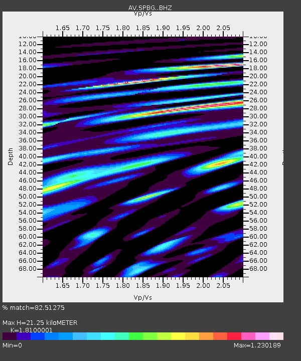
| Estimated Moho Depth: |
21.25 km |
| Estimated Crust Vp/Vs: |
1.81 |
| Assumed Crust Vp: |
6.566 km/s |
| Estimated Crust Vs: |
3.628 km/s |
| Estimated Crust Poisson's Ratio: |
0.28 |
|
| Radial Match: |
82.51275 % |
| Radial Bump: |
400 |
| Transverse Match: |
88.09816 % |
| Transverse Bump: |
400 |
| SOD ConfigId: |
13570011 |
| Insert Time: |
2019-04-30 20:54:44.774 +0000 |
| GWidth: |
2.5 |
| Max Bumps: |
400 |
| Tol: |
0.001 |
|

Signal To Noise
| Channel | StoN | STA | LTA |
| AV:SPBG: :BHZ:20180819T00:30:26.599028Z | 42.894295 | 1.2920057E-5 | 3.0120688E-7 |
| AV:SPBG: :BHN:20180819T00:30:26.599028Z | 59.504044 | 1.4634341E-5 | 2.459386E-7 |
| AV:SPBG: :BHE:20180819T00:30:26.599028Z | 64.8359 | 1.470361E-5 | 2.2678192E-7 |
| Arrivals |
| Ps | 2.7 SECOND |
| PpPs | 8.9 SECOND |
| PsPs/PpSs | 12 SECOND |


