You are here: Home > Network List > AV - Alaska Volcano Observatory Stations List
> Station SPU Mount Spurr, Mount Spurr, Alaska > Earthquake Result Viewer
SPU Mount Spurr, Mount Spurr, Alaska - Earthquake Result Viewer
| Earthquake location: |
Fiji Islands Region |
| Earthquake latitude/longitude: |
-18.2/-178.1 |
| Earthquake time(UTC): |
2018/08/19 (231) 00:19:37 GMT |
| Earthquake Depth: |
563 km |
| Earthquake Magnitude: |
8.2 mww |
| Earthquake Catalog/Contributor: |
NEIC PDE/us |
|
| Network: |
AV Alaska Volcano Observatory |
| Station: |
SPU Mount Spurr, Mount Spurr, Alaska |
| Lat/Lon: |
61.18 N/152.06 W |
| Elevation: |
800 m |
|
| Distance: |
81.8 deg |
| Az: |
12.416 deg |
| Baz: |
204.954 deg |
| Ray Param: |
0.04565264 |
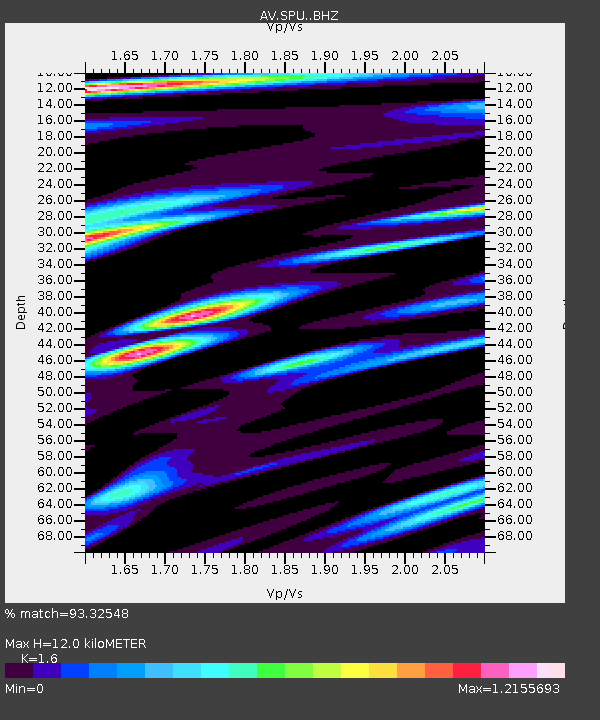
| Estimated Moho Depth: |
12.0 km |
| Estimated Crust Vp/Vs: |
1.60 |
| Assumed Crust Vp: |
6.566 km/s |
| Estimated Crust Vs: |
4.104 km/s |
| Estimated Crust Poisson's Ratio: |
0.18 |
|
| Radial Match: |
93.32548 % |
| Radial Bump: |
400 |
| Transverse Match: |
88.381226 % |
| Transverse Bump: |
400 |
| SOD ConfigId: |
13570011 |
| Insert Time: |
2019-04-30 20:54:47.269 +0000 |
| GWidth: |
2.5 |
| Max Bumps: |
400 |
| Tol: |
0.001 |
|
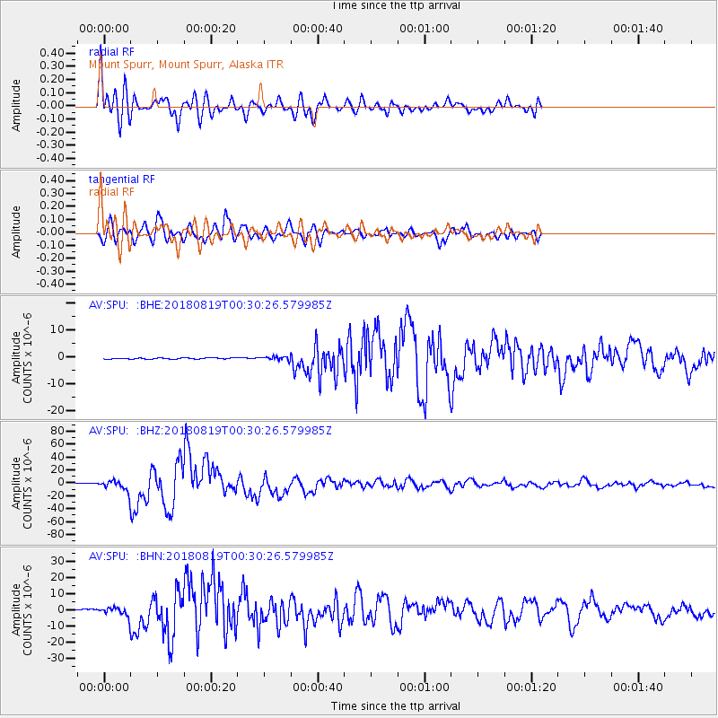
Signal To Noise
| Channel | StoN | STA | LTA |
| AV:SPU: :BHZ:20180819T00:30:26.579985Z | 14.001049 | 9.622995E-6 | 6.8730526E-7 |
| AV:SPU: :BHN:20180819T00:30:26.579985Z | 10.71728 | 3.2536448E-6 | 3.0358865E-7 |
| AV:SPU: :BHE:20180819T00:30:26.579985Z | 6.484987 | 1.4113144E-6 | 2.1762796E-7 |
| Arrivals |
| Ps | 1.1 SECOND |
| PpPs | 4.6 SECOND |
| PsPs/PpSs | 5.7 SECOND |


