You are here: Home > Network List > TA - USArray Transportable Network (new EarthScope stations) Stations List
> Station F13A Darby, MT, USA > Earthquake Result Viewer
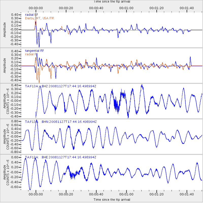
F13A Darby, MT, USA - Earthquake Result Viewer
*The percent match for this event was below the threshold and hence no stack was calculated.
| Earthquake location: |
Vanuatu Islands |
| Earthquake latitude/longitude: |
-17.8/167.6 |
| Earthquake time(UTC): |
2008/11/27 (332) 17:31:27 GMT |
| Earthquake Depth: |
10 km |
| Earthquake Magnitude: |
5.5 MB, 5.3 MS, 5.5 MW |
| Earthquake Catalog/Contributor: |
WHDF/NEIC |
|
| Network: |
TA USArray Transportable Network (new EarthScope stations) |
| Station: |
F13A Darby, MT, USA |
| Lat/Lon: |
45.79 N/114.33 W |
| Elevation: |
1462 m |
|
| Distance: |
94.6 deg |
| Az: |
43.376 deg |
| Baz: |
249.249 deg |
| Ray Param: |
$rayparam |
*The percent match for this event was below the threshold and hence was not used in the summary stack. |
|
| Radial Match: |
77.25522 % |
| Radial Bump: |
400 |
| Transverse Match: |
41.195194 % |
| Transverse Bump: |
400 |
| SOD ConfigId: |
2658 |
| Insert Time: |
2010-03-06 14:14:03.985 +0000 |
| GWidth: |
2.5 |
| Max Bumps: |
400 |
| Tol: |
0.001 |
|
Signal To Noise
| Channel | StoN | STA | LTA |
| TA:F13A: :BHN:20081127T17:44:16.498994Z | 2.2702231 | 5.2674943E-7 | 2.320254E-7 |
| TA:F13A: :BHE:20081127T17:44:16.498994Z | 1.2283688 | 4.1599023E-7 | 3.3865257E-7 |
| TA:F13A: :BHZ:20081127T17:44:16.498994Z | 0.9715037 | 1.8297202E-7 | 1.8833899E-7 |
| Arrivals |
| Ps | |
| PpPs | |
| PsPs/PpSs | |


