You are here: Home > Network List > C1 - Red Sismologica Nacional Stations List
> Station MT14 Calan > Earthquake Result Viewer
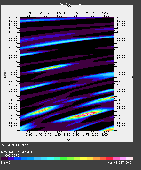
MT14 Calan - Earthquake Result Viewer
| Earthquake location: |
Fiji Islands Region |
| Earthquake latitude/longitude: |
-18.2/-178.1 |
| Earthquake time(UTC): |
2018/08/19 (231) 00:19:37 GMT |
| Earthquake Depth: |
563 km |
| Earthquake Magnitude: |
8.2 mww |
| Earthquake Catalog/Contributor: |
NEIC PDE/us |
|
| Network: |
C1 Red Sismologica Nacional |
| Station: |
MT14 Calan |
| Lat/Lon: |
33.40 S/70.54 W |
| Elevation: |
856 m |
|
| Distance: |
94.0 deg |
| Az: |
126.917 deg |
| Baz: |
245.31 deg |
| Ray Param: |
0.04060323 |
| Estimated Moho Depth: |
61.25 km |
| Estimated Crust Vp/Vs: |
1.96 |
| Assumed Crust Vp: |
6.481 km/s |
| Estimated Crust Vs: |
3.311 km/s |
| Estimated Crust Poisson's Ratio: |
0.32 |
|
| Radial Match: |
88.91658 % |
| Radial Bump: |
400 |
| Transverse Match: |
78.34911 % |
| Transverse Bump: |
400 |
| SOD ConfigId: |
13570011 |
| Insert Time: |
2019-04-30 20:55:45.701 +0000 |
| GWidth: |
2.5 |
| Max Bumps: |
400 |
| Tol: |
0.001 |
|

Signal To Noise
| Channel | StoN | STA | LTA |
| C1:MT14: :HHZ:20180819T00:31:24.623015Z | 3.2493117 | 1.6632222E-6 | 5.118691E-7 |
| C1:MT14: :HHN:20180819T00:31:24.623015Z | 2.764716 | 1.3402224E-6 | 4.8475954E-7 |
| C1:MT14: :HHE:20180819T00:31:24.623015Z | 1.7963411 | 9.728806E-7 | 5.415901E-7 |
| Arrivals |
| Ps | 9.2 SECOND |
| PpPs | 27 SECOND |
| PsPs/PpSs | 37 SECOND |


