You are here: Home > Network List > CC - Cascade Chain Volcano Monitoring Stations List
> Station PR01 Puyallup River 01 > Earthquake Result Viewer
PR01 Puyallup River 01 - Earthquake Result Viewer
| Earthquake location: |
Fiji Islands Region |
| Earthquake latitude/longitude: |
-18.2/-178.1 |
| Earthquake time(UTC): |
2018/08/19 (231) 00:19:37 GMT |
| Earthquake Depth: |
563 km |
| Earthquake Magnitude: |
8.2 mww |
| Earthquake Catalog/Contributor: |
NEIC PDE/us |
|
| Network: |
CC Cascade Chain Volcano Monitoring |
| Station: |
PR01 Puyallup River 01 |
| Lat/Lon: |
46.91 N/122.04 W |
| Elevation: |
648 m |
|
| Distance: |
82.1 deg |
| Az: |
35.055 deg |
| Baz: |
232.795 deg |
| Ray Param: |
0.045475617 |
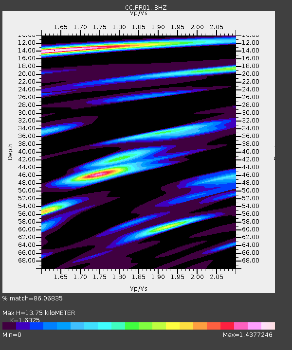
| Estimated Moho Depth: |
13.75 km |
| Estimated Crust Vp/Vs: |
1.63 |
| Assumed Crust Vp: |
6.566 km/s |
| Estimated Crust Vs: |
4.022 km/s |
| Estimated Crust Poisson's Ratio: |
0.20 |
|
| Radial Match: |
86.06835 % |
| Radial Bump: |
400 |
| Transverse Match: |
78.435 % |
| Transverse Bump: |
400 |
| SOD ConfigId: |
13570011 |
| Insert Time: |
2019-04-30 20:56:04.747 +0000 |
| GWidth: |
2.5 |
| Max Bumps: |
400 |
| Tol: |
0.001 |
|

Signal To Noise
| Channel | StoN | STA | LTA |
| CC:PR01: :BHZ:20180819T00:30:28.019988Z | 7.413369 | 2.6816938E-6 | 3.6173753E-7 |
| CC:PR01: :BHN:20180819T00:30:28.019988Z | 6.0123267 | 7.0554E-7 | 1.1734891E-7 |
| CC:PR01: :BHE:20180819T00:30:28.019988Z | 5.1165204 | 8.042148E-7 | 1.5718003E-7 |
| Arrivals |
| Ps | 1.4 SECOND |
| PpPs | 5.4 SECOND |
| PsPs/PpSs | 6.7 SECOND |


