You are here: Home > Network List > CI - Caltech Regional Seismic Network Stations List
> Station EDW2 EDW2, Mojave, CA, USA > Earthquake Result Viewer
EDW2 EDW2, Mojave, CA, USA - Earthquake Result Viewer

| Earthquake location: |
Fiji Islands Region |
| Earthquake latitude/longitude: |
-18.2/-178.1 |
| Earthquake time(UTC): |
2018/08/19 (231) 00:19:37 GMT |
| Earthquake Depth: |
563 km |
| Earthquake Magnitude: |
8.2 mww |
| Earthquake Catalog/Contributor: |
NEIC PDE/us |
|
| Network: |
CI Caltech Regional Seismic Network |
| Station: |
EDW2 EDW2, Mojave, CA, USA |
| Lat/Lon: |
34.88 N/117.99 W |
| Elevation: |
772 m |
|
| Distance: |
77.7 deg |
| Az: |
46.849 deg |
| Baz: |
237.528 deg |
| Ray Param: |
0.048383217 |
| Estimated Moho Depth: |
69.5 km |
| Estimated Crust Vp/Vs: |
1.85 |
| Assumed Crust Vp: |
6.276 km/s |
| Estimated Crust Vs: |
3.392 km/s |
| Estimated Crust Poisson's Ratio: |
0.29 |
|
| Radial Match: |
98.06067 % |
| Radial Bump: |
351 |
| Transverse Match: |
94.88854 % |
| Transverse Bump: |
400 |
| SOD ConfigId: |
13570011 |
| Insert Time: |
2019-04-30 20:56:26.089 +0000 |
| GWidth: |
2.5 |
| Max Bumps: |
400 |
| Tol: |
0.001 |
|
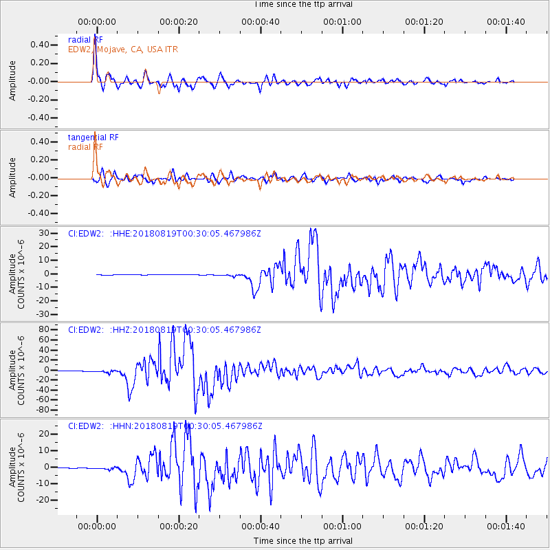
Signal To Noise
| Channel | StoN | STA | LTA |
| CI:EDW2: :HHZ:20180819T00:30:05.467986Z | 21.986671 | 2.280091E-6 | 1.0370332E-7 |
| CI:EDW2: :HHN:20180819T00:30:05.467986Z | 8.359751 | 6.1509076E-7 | 7.3577645E-8 |
| CI:EDW2: :HHE:20180819T00:30:05.467986Z | 7.2414975 | 6.43566E-7 | 8.887195E-8 |
| Arrivals |
| Ps | 9.7 SECOND |
| PpPs | 31 SECOND |
| PsPs/PpSs | 40 SECOND |


